Mons Rümker
| ||
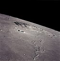
 Mons Rümker z Apollo 15 | ||
| Ciało niebieskie | Księżyc | |
| Położenie | Oceanus Procellarum | |
| Wysokość | 1100 m nad poziom odniesienia | |
| Dane wulkanu | ||
| Typ wulkanu | wulkan tarczowy | |
| Aktywność | wygasły | |
Mons Rümker – samotna formacja wulkaniczna, położona w północno-zachodniej części widocznej strony Księżyca, na północy Oceanus Procellarum (Oceanu Burz), na południe od Sinus Roris (Zatoki Rosy). Góra tworzy dużą kopułę o średnicy 70 km, wznoszącą się na wysokość 1,1 km ponad otaczającą równinę. Jej nazwa, nadana w 1935 roku upamiętnia niemieckiego astronoma Carla Ludwiga Christiana Rümkera.
Mons Rümker składa się z 30[1] kopuł, łagodnie wznoszących się na kilkaset metrów. Są one pozostałością wulkanów tarczowych, z których wypłynęła wolno stygnąca lawa. Niektóre z nich mają mały krater na szczycie.
Góra jest oddzielona skarpą od okalającego ją morza. Płaskowyż wznosi się na 0,9 km na zachodzie, 1,1 km na południu i 0,65 km na wschodzie. Jej powierzchnia jest stosunkowo jednolita; analiza spektroskopowa wskazuje na jej pochodzenie z morza księżycowego. Szacuje się, że Mons Rümker powstała z 1800 km³ lawy[1].
Zobacz też
Przypisy
- ↑ a b Wöhler, C.; Lena, R.; Pau, K. C.. The Lunar Dome Complex Mons Rümker: Morphometry, Rheology, and Mode of Emplacement. „Proceedings Lunar and Planetary Science XXXVIII”, 12-16 marca 2007. League City, Texas: Dordrecht, D. Reidel Publishing Co. [dostęp 2007-08-28].
Media użyte na tej stronie
Black up-pointing triangle ▲, U+25B2 from Unicode-Block Geometric Shapes (25A0–25FF)
Autor:
- Nuvola_apps_kmoon.png: David Vignoni / derivative work: Lady Whistler (talk)
Icon from Nuvola icon theme for KDE 3.x.
This picture of the Mons Rümker rise on the Oceanus Procellarum was taken from the Apollo 15 while in lunar orbit. The image is reduced in size by 50% from the original.
cylindrical map projection of the Moon. The Moon's whole surface was mapped by the Clementine spacecraft in 1994, here North is at the top. The dark floor of crater Plato is at the middle top above Mare Imbrium, while the bright floor and rays of crater Tycho is near the middle bottom below Mare Imbrium. Mare Procellarum is at the near left, and Mare Tranquillitatis is just right of centre and Mare Crisium is at the near right. The far left and far right show the contrast of the mostly cratered farside with small isolated mare.
(c) Luc Viatour, CC-BY-SA-3.0
Nearly Full Moon view from earth In Belgium (Hamois).


