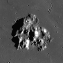
Mons Vinogradov
| ||
 | ||
| Ciało niebieskie | Księżyc | |
| Położenie | Mare Imbrium / Oceanus Procellarum | |
| Wysokość | 1400 m nad poziom odniesienia | |
Mons Vinogradov – poszarpany masyw górski położony na morzu księżycowym w miejscu, gdzie Oceanus Procellarum na południowym zachodzie łączy się z Mare Imbrium na wschodzie. Trzy najważniejsze szczyty formacji wznoszą się na wysokość 1,0-1,4 km ponad powierzchnię. Na wschód od nich leży krater Euler, a na południowy wschód przedgórza Montes Carpatus, tworzących południowo-zachodnią granicę Mare Imbrium.
Maksymalna średnica góry przy podstawie to 25 km. Jej nazwa, nadana w 1979 roku upamiętnia radzieckiego chemika Aleksandra Pawłowicza Winogradowa (1895-1975). Wcześniej była nazywana Euler Beta (β) lub Mons Euler.
W górzystym terenie tuż na południowy wschód od Mons Vinogradov leży kilka niewielkich kraterów, które zostały nazwane przez MUA. Są one wymienione poniżej.
| Krater | Współrzędne | Średnica | Pochodzenie nazwy |
|---|---|---|---|
| Akis | 20,0° N, 31,8° W | 2 km | greckie imię żeńskie |
| Ango | 20,5° N, 32,3° W | 1 km | afrykańskie imię męskie |
| Jehan[1] | 20,7° N, 31,9° W | 5 km | tureckie imię żeńskie |
| Natasha[2] | 20,0° N, 31,3° W | 12 km | rosyjskie imię żeńskie |
| Rosa | 20,3° N, 32,3° W | 1 km | hiszpańskie imię żeńskie |
Zobacz też
Przypisy
Bibliografia
- Andersson, L. E.; Whitaker, E. A., (1982). NASA Catalogue of Lunar Nomenclature. NASA RP-1097.
- Blue, Jennifer (25 lipca 2007). Mons Vinogradov in "Gazetteer of Planetary Nomenclature". USGS. Dostęp 2007-08-05.
- Bussey, B.; Spudis, P. (2004). The Clementine Atlas of the Moon. New York: Cambridge University Press. ISBN 0-521-81528-2.
- Elijah E. Cocks, Who's Who on the Moon: A Biographical Dictionary of Lunar Nomenclature, Josiah C. Cocks, wyd. 1st ed, Greensboro: Tudor Publishers, 1995, ISBN 0-936389-27-3, OCLC 32468980.
- McDowell, Jonathan (2007-07-15). "Lunar Nomenclature". Jonathan's Space Report. Dostęp 2007-10-24.
- Menzel, D. H.; Minnaert, M.; Levin, B.; Dollfus, A.; Bell, B. (1971). "Report on Lunar Nomenclature by The Working Group of Commission 17 of the IAU". Space Science Reviews 12: 136.
- Moore, Patrick (2001). On the Moon. Sterling Publishing Co.. ISBN 0-304-35469-4.
- Fred William Price, The Moon Observer's Handbook, Cambridge [Cambridgeshire]: Cambridge University Press, 1988, ISBN 0-521-33500-0, OCLC 17548914.
- Rükl, Antonín (1990). Atlas of the Moon. Kalmbach Books. ISBN 0-913135-17-8.
- Webb, Rev. T. W. (1962). Celestial Objects for Common Telescopes (6th revision ed.). Dover. ISBN 0-486-20917-2.
- Ewen Adair Whitaker, Mapping and Naming the Moon, Cambridge [England]: Cambridge University Press, 1999, ISBN 0-521-62248-4, OCLC 39633902.
- Wlasuk, Peter T. (2000). Observing the Moon. Springer. ISBN 1-85233-193-3.
Linki zewnętrzne
Media użyte na tej stronie
Black up-pointing triangle ▲, U+25B2 from Unicode-Block Geometric Shapes (25A0–25FF)
Autor:
- Nuvola_apps_kmoon.png: David Vignoni / derivative work: Lady Whistler (talk)
Icon from Nuvola icon theme for KDE 3.x.
Mons Vinogradov on the Moon, between Mare Imbrium and Oceanus Procellarum. Mosaic of photos by Lunar Reconnaissance Orbiter, made with Wide Angle Camera. Size of the image is 45×45 km, north is up.
cylindrical map projection of the Moon. The Moon's whole surface was mapped by the Clementine spacecraft in 1994, here North is at the top. The dark floor of crater Plato is at the middle top above Mare Imbrium, while the bright floor and rays of crater Tycho is near the middle bottom below Mare Imbrium. Mare Procellarum is at the near left, and Mare Tranquillitatis is just right of centre and Mare Crisium is at the near right. The far left and far right show the contrast of the mostly cratered farside with small isolated mare.
(c) Luc Viatour, CC-BY-SA-3.0
Nearly Full Moon view from earth In Belgium (Hamois).


