Montmorency-Beaufort
| miejscowość i gmina | |||
 | |||
| |||
| Państwo | |||
|---|---|---|---|
| Region | |||
| Departament | |||
| Okręg | |||
| Kod INSEE | 10253 | ||
| Powierzchnia | 9,25 km² | ||
| Populacja (1990) • liczba ludności |
| ||
| • gęstość | 12 os./km² | ||
| Kod pocztowy | 10330 | ||
| Portal | |||
Montmorency-Beaufort – miejscowość i gmina we Francji, w regionie Grand Est, w departamencie Aube.
Według danych na rok 1990 gminę zamieszkiwało 111 osób, a gęstość zaludnienia wynosiła 12 osób/km².
Bibliografia
- Francuski urząd statystyczny (fr.).
Media użyte na tej stronie
Autor: Superbenjamin, Licencja: CC BY-SA 4.0
Blank administrative map of France for geo-location purpose, with regions and departements distinguished. Approximate scale : 1:3,000,000
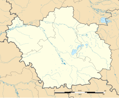
Autor: Flappiefh, Licencja: CC BY-SA 4.0
Carte administrative vierge de la région Grand Est, France, destinée à la géolocalisation.
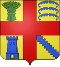
Autor: Chatsam, Licencja: CC BY-SA 3.0
blason de la commune de Montmorency-Beaufort, aube, france : d’or à la croix de gueules cantonnée au 1) d’une gerbe de blé de sinople, au 2) de trois broyes d’azur rangées en pal, au 3) d’une tour du même ouverte du champ, au 4) d’une barre ondée d’azur.
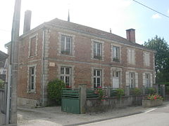
Autor: Hg marigny, Licencja: CC BY-SA 3.0
mairie de Montmorency-Beaufort
Autor: Flappiefh, Licencja: CC BY-SA 4.0
Blank administrative map of the department of Aube, France, for geo-location purpose.


