Moretonhampstead
(c) Penny Mayes, CC BY-SA 2.0 | |
| Państwo | |
|---|---|
| Kraj | |
| Hrabstwo | |
| Populacja (2002) • liczba ludności |
|
| Nr kierunkowy | 01647 |
| Kod pocztowy | TQ13 |
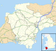
Położenie na mapie Devonu Contains Ordnance Survey data © Crown copyright and database right, CC BY-SA 3.0 | |
Położenie na mapie Wielkiej Brytanii (c) Karte: NordNordWest, Lizenz: Creative Commons by-sa-3.0 de | |
| Strona internetowa | |
| Portal | |
Moretonhampstead - miasto w Wielkiej Brytanii, w Anglii w hrabstwie Devon, położone na skraju Parku Narodowego Dartmoor w dolinie Wray. W 2002 roku uzyskała tytuł Village of the Year[1]. Mimo oficjalnego statusu miasta miejscowość zachowuje wiejski charakter[2].
Zabytki
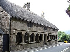
- Almshouses - domy w stylu jakobińskim z XVII wieku[2]
- Mearsdon Manor - dworek z XIII wieku zbudowany przez księcia Devonu, Philipa Courtenaya.
Nazwa
Pochodzi od saksońskiego słowa mortun oznaczającego teren w pobliżu wrzosowiska. Drugi człon - "Hampstead" dodano później. Jest uważana za najdłuższą pojedynczą nazwę miejscowości w Anglii[3].
Miasto partnerskie
Przypisy
- ↑ Moretonhampstead (ang.). [dostęp 2008-09-15].
- ↑ a b Moretonhampstead (ang.). [dostęp 2008-09-15]. [zarchiwizowane z tego adresu (2008-09-13)].
- ↑ United Kingdom Research Guide (ang.). [dostęp 2008-09-15].
Media użyte na tej stronie
Contains Ordnance Survey data © Crown copyright and database right, CC BY-SA 3.0
Map of Devon, UK with the following information shown:
- Administrative borders
- Coastline, lakes and rivers
- Motorways and primary routes
- Urban areas
Equirectangular map projection on WGS 84 datum, with N/S stretched 150%
Geographic limits:
- West: 4.72W
- East: 2.86W
- North: 51.3N
- South: 50.16N
(c) Karte: NordNordWest, Lizenz: Creative Commons by-sa-3.0 de
Location map of the United Kingdom
Flag of England. Saint George's cross (a red cross on a white background), used as the Flag of England, the Italian city of Genoa and various other places.
(c) Penny Mayes, CC BY-SA 2.0
Almshouses, Moretonhampstead. They stand on Cross Street, in front of the church of St Andrew. The date stone says 1637 but is thought to be the remodelling of an earlier building, possibly part of the mediaeval hospital founded here in 1451.


