Morvi
| ||
 | ||
| Państwo | ||
| Nr kierunkowy | 2822 | |
| Kod pocztowy | 363641 | |
Położenie na mapie Indii | ||
Morvi (czasem spotykana jest też nazwa Morbi) – miasto w zachodnich Indiach, w stanie Gudźarat. Położone jest nad rzeką Manchhu. Dawniej w jego pobliżu znajdowała się zapora wodna Morvi. 12 sierpnia 1979 doszło do jej wysadzenia, w wyniku czego ściana wody, która runęła z potężną siłą ze zbiornika nad zaporą zniszczyła miasto, zabijając według różnych źródeł od 1500 do 12000 osób.
Media użyte na tej stronie
(c) Uwe Dedering z niemieckiej Wikipedii, CC BY-SA 3.0
Location map of India.
Equirectangular projection. Strechted by 106.0%. Geographic limits of the map:
- N: 37.5° N
- S: 5.0° N
- W: 67.0° E
- E: 99.0° E
The Flag of India. The colours are saffron, white and green. The navy blue wheel in the center of the flag has a diameter approximately the width of the white band and is called Ashoka's Dharma Chakra, with 24 spokes (after Ashoka, the Great). Each spoke depicts one hour of the day, portraying the prevalence of righteousness all 24 hours of it.
Autor: Nitish.mano, Licencja: CC BY-SA 4.0
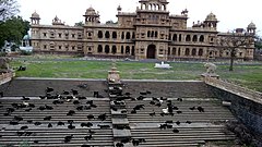
A beautiful heritage name "MANI MANDIR" in Morbi,Gujarat
Autor: Maximilian Dörrbecker (Chumwa), Licencja: CC BY-SA 3.0
Location map of Gujarat


