Morze Amundsena
| ||
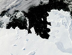
 Wybrzeże Walgreena i Morze Amundsena – zdjęcie satelitarne | ||
| Kontynent | Antarktyda | |
| Powierzchnia | 98 tys. km² | |
| Największa głębia | 585 m | |
| Zasolenie | 32–34‰ | |
| Temperatura | 0,2 °C do –1,8 °C | |
| Typ morza | szelfowe | |
| Wyspy | Wyspa Carneya, Wyspa Siple’a | |
 | ||
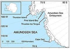
Morze Amundsena – przybrzeżne morze szelfowe, część Oceanu Spokojnego u wybrzeży Antarktydy (nad Ziemią Marii Byrd) między 100° a 123°W, lokalizowane czasem także pomiędzy przylądkiem Dart na Wyspie Siple’a (ok. 124°W) a Wyspą Thurstona (ok. 103°W). Powierzchnia 98 tys. km²; głębokość do 585 m; temperatura wód powierzchniowych od 0,2 °C do –1,8 °C, zasolenie 32–34‰. Przez cały rok pokryte jest lodem morskim; ok. 1/3 linii brzegowej zajmują bariery lodowców szelfowych, z których największym jest Lodowiec Szelfowy Getza.
Pierwszy na Morze Amundsena dotarł James Cook na przełomie lat 1773 i 1774.
Współcześnie morze to odznacza się najszybszym rozpadem lodowców szelfowych na całej Ziemi[1].
Przypisy
Media użyte na tej stronie
Map of the Amundsen Sea area of Antarctica
Autor: Alexrk2, Licencja: CC BY-SA 3.0
Physical Location map Antarctica, Azimuthal equidistant projection
Pine Island Bay is tucked into a corner of the West Antarctic’s Walgreen Coast. The bay, which opens to the Amundsen Sea, is typically filled with sea ice at this time of year, but when this image was taken, the bay was largely ice-free. Acquired at the end of the Antarctic summer, the image is illuminated by fairly low-angled sunlight, which highlights raised and textured areas, including ice-covered peninsulas and the corrugated surface of iceberg B-22A. B-22A broke from the Mertz Glacier Tongue several thousand miles to the west; it may be grounded on a submarine shoal. Northwest of the iceberg is a combination of sea ice and grounded icebergs. This sea ice/iceberg feature has been larger in recent Antarctic summers than it appears in this image. The coast of Antarctica not only has sea ice that comes and goes from year to year, but also longer-lasting ice shelves (thick slabs of ice attached to the coastline that partially float on the ocean surface). Among the ice shelves on the Walgreen Coast is Dotson Ice Shelf. Although most of the surface appears smooth, several long cracks appear to trace the leading edge of the shelf, hinting that the margin may calve some long, narrow icebergs in coming summers. The presence or absence of sea ice affects both ocean surface waters and ice shelves. Thanks to its light colour, sea ice reflects much of the Sun’s energy back into space, keeping underlying ocean waters cool. Without a cover of sea ice, the surface waters of the ocean warm. The exposure to sunlight also makes it possible for phytoplankton to bloom. West of the line of grounded icebergs, the ice floating in the Amundsen Sea takes on a greenish colour; this may be due to phytoplankton or algae. When it comes to ice shelves, a sea-ice cap on the ocean surface dampens wave energy that might otherwise trigger ice-shelf retreat.


