Morze Czukockie
| ||
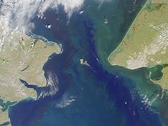
 Morze Czukockie z satelity | ||
| Kontynent | Azja, Ameryka Północna | |
| Państwa | ||
| Powierzchnia | 582 tys. km² | |
| Średnia głębokość | 77 m | |
| Największa głębia | 1256 m | |
| Zasolenie | 27–36‰ | |
| Temperatura | zima 0 °C do -1,7 °C, lato ok. 7[1] °C | |
| Typ morza | otwarte | |
| Wyspy | Wyspa Wrangla | |
 Morze Czukockie na mapie politycznej | ||
Morze Czukockie (ros. Чукотское море, ang. Chukchi Sea) – część Oceanu Arktycznego leżąca za północnym kołem podbiegunowym, pomiędzy wybrzeżem Alaski a Syberią. Morze Czukockie połączone jest Cieśniną De Longa z Morzem Wschodniosyberyjskim, na wschodzie sąsiaduje z Morzem Beauforta, a na południu łączy się z Oceanem Spokojnym za pośrednictwem Cieśniny Beringa.
Nazwa pochodzi od plemienia Czukczów zamieszkujących północno-wschodni kraniec Rosji, w tym Półwysep Czukocki. Przez Morze Czukockie przechodzi linia zmiany daty.
Warunki klimatyczne
Klimat mroźny. Morze Czukockie jest żeglowne od lipca do października. W okresie zimowym cała powierzchnia Morza Czukockiego pokryta jest lodem. Linia brzegowa jest stosunkowo słabo rozwinięta. Wzdłuż wybrzeża rosyjskiego występują prądy unoszące góry lodowe.
Gospodarka
Rybołówstwo obejmuje głównie połowy dorsza. Poluje się także na morsy i foki.
Przypisy
- ↑ część południowa
Bibliografia
- Encyklopedia Audiowizualna Britannica – Geografia I, Rafał Jasiulewicz (red.), Leszek Baraniecki, Poznań: Wydawnictwo Kurpisz, 2006, ISBN 83-60563-07-1, ISBN 978-83-60563-07-6, ISBN 83-60563-04-7, ISBN 978-83-60563-04-5, ISBN 1-59339-330-X, ISBN 978-1-59339-330-4, OCLC 838992809.
Media użyte na tej stronie
Autor: Wikisoft* @@@-fr 07:08, 27 April 2011 (UTC), Licencja: GFDL
Carte Alaska Relief R3 jpg (Changement des couleurs)
The flag of Navassa Island is simply the United States flag. It does not have a "local" flag or "unofficial" flag; it is an uninhabited island. The version with a profile view was based on Flags of the World and as a fictional design has no status warranting a place on any Wiki. It was made up by a random person with no connection to the island, it has never flown on the island, and it has never received any sort of recognition or validation by any authority. The person quoted on that page has no authority to bestow a flag, "unofficial" or otherwise, on the island.
Bering strait, image taken by MISR satellite.
With the Seward Peninsula of Alaska to the east, and Chukotskiy Poluostrovof Siberia to the west, the Bering Strait separates the United States and the Russian Federation by only 90 kilometers. It is named for Danish explorer Vitus Bering, who spotted the Alaskan mainland in 1741 while leading an expedition of Russian sailors. This view of the region was captured by MISR's vertical-viewing (nadir) camera on August 18, 2000 during Terra orbit 3562.
The boundary between the US and Russia lies between Big and Little Diomede Islands, which are visible in the middle of the Bering Strait. The Arctic Circle, at 66.5 degrees north latitude, runs through the Arctic Ocean in the top part of this image. This circle marks the southernmost latitude for which the Sun does not rise above the horizon on the day of the winter solstice. At the bottom of this image is St. Lawrence Island. Situated in the Bering Sea, it is part of Alaska and home to Yupik Eskimos.
MISR was built and is managed by NASA's Jet Propulsion Laboratory, Pasadena, CA, for NASA's Office of Earth Science, Washington, DC. The Terra satellite is managed by NASA's Goddard Space Flight Center, Greenbelt, MD. JPL is a division of the California Institute of Technology. For more information: http://www-misr.jpl.nasa.govAutor: Das steinerne Herz, Licencja: CC BY-SA 3.0
Chukotka_Autonomous_Okrug_relief_location_map
Autor: Oryginalnym przesyłającym był Mohonu z angielskiej Wikipedii, Licencja: CC-BY-SA-3.0
Map showing the location of the Chukchi Sea. Modified map based on map en:commons:Image:Chukchi Sea map.png created by NormanEinstein, May 31, 2006.


