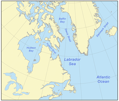
Morze Labradorskie
| ||
 Zachód słońca nad morzem w Paamiut | ||
| Kontynent | Ameryka Północna | |
| Państwa | ||
| Terytoria | ||
| Powierzchnia | 841 000 km² | |
| Średnia głębokość | 1898 m | |
| Największa głębia | 4316 m | |
 | ||
Morze Labradorskie – morze stanowiące odnogę Oceanu Atlantyckiego, znajdujące się między Grenlandią a Ameryką Północną. Jego głębokość sięga 4 kilometrów, z trzech stron otoczone jest szelfem kontynentalnym.
Media użyte na tej stronie
Autor: Uwe Dedering, Licencja: CC BY-SA 3.0
Relief location map of North America.
- Projection: Lambert azimuthal equal-area projection.
- Area of interest:
- N: 90.0° N
- S: 5.0° N
- W: -140.0° E
- E: -60.0° E
- Projection center:
- NS: 47.5° N
- WE: -100.0° E
- GMT projection: -JA-100/47.5/20.0c
- GMT region: -R-138.3726888474925/-3.941007863604182/2.441656573833029/50.63933645705661r
- GMT region for grdcut: -R-220.0/-4.0/20.0/90.0r
- Relief: SRTM30plus.
- Made with Natural Earth. Free vector and raster map data @ naturalearthdata.com.
Autor: Algkalv (talk), Licencja: CC BY-SA 3.0
Past sunset at Labrador Sea, off the coast of Paamiut, Greenland. Photographed from the top deck of Sarfaq Ittuk of Arctic Umiaq Line.


