Morze Sargassowe
 Morze Sargassowe | |
| Kontynent | |
|---|---|
| Państwa | |
| Terytoria | |
| Powierzchnia | ok. 6–7 mln[1] km² |
| Typ morza | |
Morze Sargassowe (ang. Sargasso Sea) – morze Oceanu Atlantyckiego.
Na obszarze Morza Sargassowego znajdują się Bermudy[1]. Po raz pierwszy wspomniał o tym morzu Krzysztof Kolumb w trakcie swojej wyprawy w 1492 roku[2].
Leży w zwrotnikowych szerokościach geograficznych – między równoleżnikami 20°N i 35°N i południkami 30°W i 70°W[2]; także pomiędzy prądami Zatokowym, Kanaryjskim i Północnorównikowym. Szacunkowa powierzchnia to 6–7 mln km²[1]. Osiąga głębokość 1500–7000 m[2].
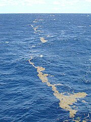
Morze Sargassowe to obszar względnego bezruchu (halistazy). Gęsto porośnięte przez gronorosty (Sargassum), występują powiązane z nimi organizmy. Średnia temperatura wód powierzchniowych w zimie 18–23 °C, w lecie 25–28 °C. Zasolenie 36,5–37‰[1]. Miejsce tarła węgorzy: europejskiego i amerykańskiego[1], kongerów: amerykańskiego i białopłetwego oraz kilku innych gatunków ryb węgorzokształtnych[3].
Zobacz też
Przypisy
- ↑ a b c d e Encyklopedia Powszechna PWN. T. 3. M–R. Warszawa: Państwowe Wydawnictwo Naukowe, 1975, s. 140.
- ↑ a b c Sargasso Sea, [w:] Encyclopædia Britannica [online] [dostęp 2014-06-18] (ang.).
- ↑ Miller Michael J. & Hanel Reinhold: The Sargasso Sea subtropical gyre : the spawning and larval development area of both freshwater and marine eels. Washington, D.C.: Secretariat of the Sargasso Sea Alliance, 2011. ISBN 978-0-9847520-9-6.
Linki zewnętrzne
- Jaka jest historia Morza Sargassowego? (The Straight) [dostęp 2010-05-26] (ang.)
Media użyte na tej stronie
The flag of Navassa Island is simply the United States flag. It does not have a "local" flag or "unofficial" flag; it is an uninhabited island. The version with a profile view was based on Flags of the World and as a fictional design has no status warranting a place on any Wiki. It was made up by a random person with no connection to the island, it has never flown on the island, and it has never received any sort of recognition or validation by any authority. The person quoted on that page has no authority to bestow a flag, "unofficial" or otherwise, on the island.
Autor: Uwe Dedering, Licencja: CC BY-SA 3.0
Relief location map of Atlantic_Ocean.
- Projection: Lambert azimuthal equal-area projection.
- Area of interest:
- N: 70.0° N
- S: -70.0° N
- W: -95.0° E
- E: 25.0° E
- Projection center:
- NS: 0.0° N
- WE: -35.0° E
- GMT projection: -JA-35.0/0.0/180/19.998266666666666c
- GMT region: -R-147.58842045747764/-48.58942183011819/77.58842045747762/48.589421830118205r
- GMT region for grdcut: -R-148.0/-76.0/78.0/76.0r
- Relief: SRTM30plus.
- Made with Natural Earth. Free vector and raster map data @ naturalearthdata.com.
These lines of sargassum can stretch for miles along the surface. The clumps of floating algae are often concentrated by the strong winds and wave action associated with the Gulf Stream.


