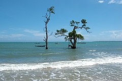
Morze Sulu
© Vyacheslav Argenberg / http://www.vascoplanet.com/, CC BY 4.0 Widok na Morze Sulu z wyspy Palawan | |
| Kontynent | |
|---|---|
| Państwa | |
| Powierzchnia | 335 tys. km² |
| Średnia głębokość | 1570 m |
| Największa głębia | 7022 m |
| Typ morza | międzywyspowe |
Morze Sulu – morze między malezyjską częścią Borneo, a filipińskimi wyspami: Palawan, Mindoro, Panay, Negros i Mindanao, połączone cieśninami z morzem Celebes i Morzem Południowochińskim. Powierzchnia morza wynosi 335 tys. km², zaś średnia głębokość 1570 metrów. Teren aktywnych połowów ryb. Główne porty to: Puerto Princesa, Iloilo, Zamboanga i Sandakan.
Bibliografia
- Sulu Sea. W: Donald G. Groves, Lee M. Hunt: Ocean World Encyclopedia. New York: McGraw Hill, 1980, s. 374. ISBN 0-07-025010-3.
Media użyte na tej stronie
Autor: NordNordWest, Licencja: CC BY 3.0
Location map of the Philippines
© Vyacheslav Argenberg / http://www.vascoplanet.com/, CC BY 4.0
Palawan, an ecosystem of virgin forests, endemic species, pristine beaches and clear waters. A very special endemic place on the east side of Palawan Island close to smaller South Verde Island. There's lots of endemic flora on Palawan but this particular place appears to be endemic to Palawan itself. Endemic flora which are unique to specific regions present opportunities to study the past. Trees and plants always have evolved from previous populations somewhere else, but they ended up getting isolated from other populations, and then drifted to become distinct species in a group. They are not completely unique and will most often still breed with other species in the genus. This Palawan place might have had an isolated microclimate that kept it unique for thousands of years. Roxas, Palawan, Sulu Sea, Philippines.


