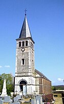
Moulicent
| miejscowość | |||
 Kościół w miejscowości Moulicent | |||
| |||
| Państwo | |||
|---|---|---|---|
| Region | |||
| Departament | |||
| Okręg | |||
| Kod INSEE | 61296 | ||
| Powierzchnia | 34,71 km² | ||
| Populacja (2013) • liczba ludności |
| ||
| Kod pocztowy | 61290 | ||
| Portal | |||
Moulicent – miejscowość i dawna gmina we Francji, w regionie Normandia, w departamencie Orne. W 2013 roku jej populacja wynosiła 291 mieszkańców[1].
W dniu 1 stycznia 2016 roku z połączenia ośmiu ówczesnych gmin – La Lande-sur-Eure, Longny-au-Perche, Malétable, Marchainville, Monceaux-au-Perche, Moulicent, Neuilly-sur-Eure oraz Saint-Victor-de-Réno – powstała nowa gmina Longny-les-Villages. Siedzibą gminy została miejscowość Longny-au-Perche[2].
Przypisy
- ↑ Populations légales 2013. INSEE. [dostęp 2016-12-20]. (fr.).
- ↑ Recueil des Actes Administratif. orne.gouv.fr. [dostęp 2016-12-20]. (fr.).
Media użyte na tej stronie
Autor: Eric Gaba (Sting - fr:Sting), Licencja: CC BY-SA 3.0
Blank administrative map of the department of Orne, France, for geo-location purpose.
Autor: Superbenjamin, Licencja: CC BY-SA 4.0
Blank administrative map of France for geo-location purpose, with regions and departements distinguished. Approximate scale : 1:3,000,000
Autor: Flappiefh, Licencja: CC BY-SA 4.0
Carte administrative vierge de la région Normandie, France, destinée à la géolocalisation.
Autor: Chatsam, Licencja: CC BY-SA 3.0
blason de la commune
D'azur au mont d'argent accompagné en chef dextre d'une lune en décours d'or, en chef senestre d'un soleil couchant du même et en abîme d'un écusson cousu de gueules chargé de cinq écussons d'argent; à la bordure cousue de sinople.Autor: TEQUILA30, Licencja: CC BY-SA 3.0
Eglise_Saint-denis_Moulicent_2


