Mount Anderson
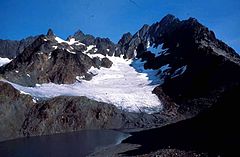
 Mount Anderson z lodowcem Anderson Glacier | |
| Państwo | |
|---|---|
| Stan | |
| Położenie | |
| Pasmo | |
| Wysokość | 2245[1] m n.p.m. |
| Wybitność | 219 m |
| Pierwsze wejście | 1920 |
Mount Anderson – szczyt w USA, w stanie Waszyngton (Hrabstwo Jefferson), położony 75 km na zachód od Seattle. Jest to jeden z wyższych szczytów gór Olympic Mountains[2]. Szczyt leży na centrum Parku Narodowego Olympic, w masywie Anderson[3][1], 30 km na wschód od Mount Olympus. Nazwę szczytowi nadano dla uczczenia Thomasa M. Andersona, bohatera wojny filipińsko-amerykańskiej[4].
Ze szczytu spływają dwa duże lodowce, od północy Eeel Glacier i od południa Andreson Glacier. Na wierzchołek można się wspiąć pokonując 38 km szlak (w tym około 1 km po lodowcu) wiodący z Dosewallips[1]
Przypisy
- ↑ a b c Mount Anderson. SummitPost.org. [dostęp 2016-03-03]. (ang.).
- ↑ Olympic Mountains. Peakbagger.org. [dostęp 2016-03-03]. (ang.).
- ↑ Olympic National Park, Washington. National Park Service. [dostęp 2016-03-03]. (ang.).
- ↑ Alison E. Swing: Cultural Wilderness: How the Historical Evolution of American Wilderness Values Influence Cultural Resource Management within Wilderness Areas in National Parks. [dostęp 2016-03-03]. (ang.).
Media użyte na tej stronie
The flag of Navassa Island is simply the United States flag. It does not have a "local" flag or "unofficial" flag; it is an uninhabited island. The version with a profile view was based on Flags of the World and as a fictional design has no status warranting a place on any Wiki. It was made up by a random person with no connection to the island, it has never flown on the island, and it has never received any sort of recognition or validation by any authority. The person quoted on that page has no authority to bestow a flag, "unofficial" or otherwise, on the island.
Black up-pointing triangle ▲, U+25B2 from Unicode-Block Geometric Shapes (25A0–25FF)
Anderson Glacier, Mount Anderson, Olympic National Park, date unknown. Photographer: Garland, M. Photo shows "Mt. Anderson & Anderson Glacier, south side of mountain."
Autor: Carport, Licencja: CC BY-SA 3.0
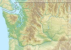
Physical location map of Washington, USA
Autor: Uwe Dedering, Licencja: CC BY-SA 3.0
Relief location map of the USA (without Hawaii and Alaska).
EquiDistantConicProjection : Central parallel :
* N: 37.0° N
Central meridian :
* E: 96.0° W
Standard parallels:
* 1: 32.0° N
* 2: 42.0° N
Made with Natural Earth. Free vector and raster map data @ naturalearthdata.com.
Formulas for x and y:
x = 50.0 + 124.03149777329222 * ((1.9694462586094064-({{{2}}}* pi / 180))
      * sin(0.6010514667026994 * ({{{3}}} + 96) * pi / 180))
y = 50.0 + 1.6155950752393982 * 124.03149777329222 * 0.02613325650382181
      - 1.6155950752393982  * 124.03149777329222 *
     (1.3236744353715044  - (1.9694462586094064-({{{2}}}* pi / 180))
      * cos(0.6010514667026994 * ({{{3}}} + 96) * pi / 180))


