Mount Haast
| ||
 | ||
| Państwo | ||
| Położenie | Westland District↗ | |
| Pasmo | Alpy Południowe | |
| Wysokość | 3114 m n.p.m. | |
| Wybitność | 127 m | |
Mount Haast – dziewiąty pod względem wysokości szczyt Nowej Zelandii, położony w Alpach Południowych.
Bibliografia
- Mount Haast (ang.)
Media użyte na tej stronie
Flag of New Zealand.svg
Flag of New Zealand. Specification: http://www.mch.govt.nz/nzflag/description.html , quoting New Zealand Gazette, 27 June 1902.
Flag of New Zealand. Specification: http://www.mch.govt.nz/nzflag/description.html , quoting New Zealand Gazette, 27 June 1902.
U+25B2.svg
Black up-pointing triangle ▲, U+25B2 from Unicode-Block Geometric Shapes (25A0–25FF)
Black up-pointing triangle ▲, U+25B2 from Unicode-Block Geometric Shapes (25A0–25FF)
New Zealand relief map.jpg
Autor:
Location map of New Zealand
Autor:
- New_Zealand_location_map.svg: NordNordWest
- derivative work: Виктор В (talk)
Location map of New Zealand
Hochstetter ice fall.jpg
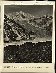
Hochstetter ice fall, photographed from the medial moraine, probably by Joseph James Kinsey. Also shows Mount Silberhorn, Mount Tasman, Mt Lendenfeld, and Mount Haast.
Hochstetter ice fall, photographed from the medial moraine, probably by Joseph James Kinsey. Also shows Mount Silberhorn, Mount Tasman, Mt Lendenfeld, and Mount Haast.


