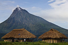
Mount Mikeno
 | |
| Państwo | |
|---|---|
| Pasmo | |
| Wysokość | 4387 m n.p.m. |
Mount Mikeno – drzemiący wulkan w paśmie górskim Wirunga we wschodniej Afryce.
Leży na północny zachód od wulkanu Karisimbi na terenie Parku Narodowego Wirunga w pobliżu granicy z Rwandą[1]. Wznosi się na wysokość 4387 m n.p.m.[2][a] i jest drugim, po Karisimbi, najwyższym szczytem Wirungi[1].
Uwagi
Przypisy
Bibliografia
- Mount Mikeno, [w:] Encyclopædia Britannica [online] [dostęp 2020-04-19] (ang.).
- Smithsonian Institution: Mikeno. [w:] Global Volcanism Program [on-line]. [dostęp 2020-04-19]. (ang.).
Media użyte na tej stronie
The national flag of the Democratic Republic of the Congo. Created according to the 2006 constitution : Son emblème est le drapeau bleu ciel, orné d’une étoile jaune dans le coin supérieur gauche et traversé en biais d’une bande rouge finement encadrée de jaune. (Its symbol is a sky blue flag, decorated with a yellow star in the upper left corner and crossed in the diagonal by a red strip with thin yellow borders) It seems to be identical, except for a lighter field hue, to the 1966–1971 flag.
Black up-pointing triangle ▲, U+25B2 from Unicode-Block Geometric Shapes (25A0–25FF)
Autor: Uwe Dedering, Licencja: CC BY-SA 3.0
Relief location map of Democratic_Republic_of_the_Congo.
- Projection: Equirectangular projection, stretched by 100.0%.
- Geographic limits of the map:
- N: 6.0° N
- S: -14.0° N
- W: 11.0° E
- E: 32.0° E
- GMT projection: -JX19.473333333333333cd/18.546031746031744cd
- GMT region: -R11.0/-14.0/32.0/6.0r
- GMT region for grdcut: -R11.0/-14.0/32.0/6.0r
- Relief: SRTM30plus.
- Made with Natural Earth. Free vector and raster map data @ naturalearthdata.com.
Autor: Cai Tjeenk Willink, Licencja: CC BY-SA 3.0
Bukima Patrol Post Tented camp in Eastern DRC Virunga National Park, with Mt Mikeno visible behind.


