Murray Hill
| Ten artykuł od 2022-07 wymaga zweryfikowania podanych informacji. |
 | |
| Państwo | |
|---|---|
| Terytorium zewnętrzne | |
| Położenie | |
| Pasmo | |
| Wysokość | 356 m n.p.m. |
| Wybitność | 356 m |
Murray Hill – najwyższy szczyt na Wyspie Bożego Narodzenia będącej terytorium zależnym Australii.
Linki zewnętrzne
Media użyte na tej stronie
U+25B2.svg
Black up-pointing triangle ▲, U+25B2 from Unicode-Block Geometric Shapes (25A0–25FF)
Black up-pointing triangle ▲, U+25B2 from Unicode-Block Geometric Shapes (25A0–25FF)
Christmas Island relief location map.svg
Autor:
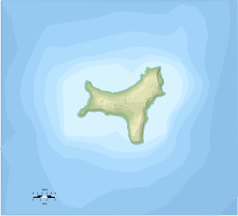
Blank Topographic map in French of Christmas Island , Australie
Autor:
- Christmas_Island_Australia_76-fr.svg: Ewan ar Born
- derivative work: Xfigpower (pssst)
Blank Topographic map in French of Christmas Island , Australie
Map of Christmas Island 1976.jpg
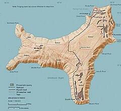
Map of Christmas. This map was produced by the U.S. Central Intelligence Agency, unless otherwise indicated. Maps dated 1976 were taken from The Indian Ocean Atlas, published by the Central Intelligence Agency.
Map of Christmas. This map was produced by the U.S. Central Intelligence Agency, unless otherwise indicated. Maps dated 1976 were taken from The Indian Ocean Atlas, published by the Central Intelligence Agency.


