Mweru
| ||
 | ||
| Położenie | ||
| Państwo | ||
|---|---|---|
| Wysokość lustra | 931 m n.p.m. | |
| Morfometria | ||
| Powierzchnia | 4920 km² | |
| Głębokość • maksymalna | 15 m | |
| Hydrologia | ||
| Rodzaj jeziora | tektoniczne | |
| 9°10′00″S 28°30′00″E/-9,166667 28,500000 | ||
Mweru (ang. Lake Mweru, fr. Lac Moero) – jezioro tektoniczne w Afryce, położone na pograniczu Demokratycznej Republiki Konga i Zambii, ok. 150 km na zachód od jeziora Tanganika, w odgałęzieniu Wielkich Rowów Afrykańskich.
- Powierzchnia: 4920 km²
- Głębokość maksymalna: 15 m
- Wysokość: 931 m n.p.m.
Przez jezioro Mweru przepływa rzeka Luapula.
Jezioro Mweru zostało odkryte dla Europejczyków w 1867 roku przez Davida Livingstone’a.
Media użyte na tej stronie
The national flag of the Democratic Republic of the Congo. Created according to the 2006 constitution : Son emblème est le drapeau bleu ciel, orné d’une étoile jaune dans le coin supérieur gauche et traversé en biais d’une bande rouge finement encadrée de jaune. (Its symbol is a sky blue flag, decorated with a yellow star in the upper left corner and crossed in the diagonal by a red strip with thin yellow borders) It seems to be identical, except for a lighter field hue, to the 1966–1971 flag.
Autor: Tzugaj, Licencja: CC0
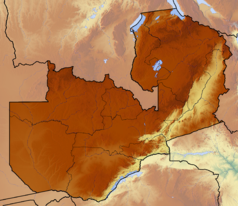
znak graficzny do map, ukazujący przykładowe jezioro
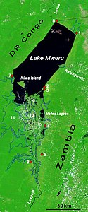
Lake Mweru, Democratic Republic of the Congo and Zambia - June 1993
- The southern end of Lake Mweru, a large freshwater lake with a maximum depth of at least 80 feet (25 meters), is visible in this near-vertical, color infrared photograph. The lake forms part of the border between Zaire to the west and Zambia to the east. The lake, noted for its large fisheries, is part of the Bangweulu wetland system and the Luapula River, which flows northward through the lake and is a headstream of the Zaire (Congo) River. The Luapula River's main channel, south of the lake, meanders through the swampy floodplain where many open bodies of water are identified as dark features within the heavily vegetated marshland. The roughly triangular lake island near the southern end of Lake Mweru belongs to Zambia. Visible west of the lake is the northern portion of the Kundelungu Mountains, a range of low mountains and escarpments, through which a roadway winds between some of the more elevated landforms. The reddish pink color on color infrared film designates green vegetation and indicates areas with dense foliage south and west of the lake.
The lower Luapula River, its delta where it enters Lake Mweru, and Mweru's outlet, the Luvua River going on north to the Lualaba and Congo rivers. Water shows up as black in this false-colour NASA satellite image. The extent of the Luapula Swamps is shown by the solid blue line, and the extent of the floodplain is shown as a dotted line. The towns are, in Zambia: 1 Chiengi, 2 Kashikishi, 3 Nchelenge, 4 Mwansabombwe, 5 Mwense; in DR Congo: 6 Pweto, 7 Kilwa, 8 Kasenga. Other features: 9 Chisenga Island, 10 the largest swamp island (in DR Congo), 11 the main floodplain.


