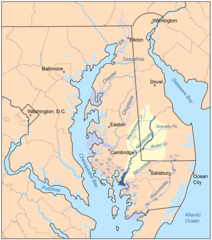
Nanticoke River
| Ten artykuł od 2014-04 wymaga zweryfikowania podanych informacji. |
 Dorzecze rzeki Nanticoke | |
| Kontynent | |
|---|---|
| Państwo | |
| Rzeka | |
| Długość | 103,5 km |
| Ujście | |
| Recypient | |
| Miejsce | Zatoka Chesapeake |
Nanticoke (ang. Nanticoke River) – rzeka na półwyspie Delmarva w amerykańskich stanach Delaware i Maryland. Uchodzi do zatoki Chesapeake. Nanticoke ma 48 km długości.
Zobacz też
Media użyte na tej stronie
The flag of Navassa Island is simply the United States flag. It does not have a "local" flag or "unofficial" flag; it is an uninhabited island. The version with a profile view was based on Flags of the World and as a fictional design has no status warranting a place on any Wiki. It was made up by a random person with no connection to the island, it has never flown on the island, and it has never received any sort of recognition or validation by any authority. The person quoted on that page has no authority to bestow a flag, "unofficial" or otherwise, on the island.
Autor: Autor nie został podany w rozpoznawalny automatycznie sposób. Założono, że to Kmusser (w oparciu o szablon praw autorskich)., Licencja: CC BY-SA 2.5
This is a map of the rivers of the Eastern Shore of Maryland with the Nanticoke River and its watershed highlighted. I made it using USGS data.

