National Maritime Museum
 Fasada muzeum | |
| Państwo | |
|---|---|
| Miejscowość | |
| Adres | Romney Road, |
| Data założenia | 1934 |
Położenie na mapie gminy Greenwich  Contains Ordnance Survey data © Crown copyright and database right, CC BY-SA 3.0 | |
Położenie na mapie Wielkiej Brytanii  (c) Karte: NordNordWest, Lizenz: Creative Commons by-sa-3.0 de | |
Położenie na mapie Anglii  | |
Położenie na mapie Wielkiego Londynu  Contains Ordnance Survey data © Crown copyright and database right, CC BY-SA 3.0 | |
| Strona internetowa | |
National Maritime Museum (NMM) w Greenwich w Londynie jest najważniejszym muzeum morskim w Zjednoczonym Królestwie i jednym z największych muzeów tego typu na świecie. Historyczne budynki − wraz z Królewskim Obserwatorium Astronomicznym i XVII-wiecznym pałacem Queen's House − zostały wpisane na listę światowego dziedzictwa UNESCO. W roku 2012 królowa Elżbieta II podpisała dekret, na mocy którego National Maritime Museum, Queen's House, Królewskie Obserwatorium Astronomiczne i żaglowiec Cutty Sark zostały objęte wspólną nazwą Królewskich Muzeów w Greenwich (Royal Museums Greenwich). NMM jest sponsorowane przez Ministerstwo Kultury i Sportu Wielkiej Brytanii. Wstęp, jak w innych muzeach publicznych Zjednoczonego Królestwa, jest bezpłatny, jednak za wstęp na niektóre wystawy czasowe opłaty są pobierane.
Oficjalne otwarcie
Muzeum zostało utworzone na podstawie National Maritime Act z roku 1934[1]. Podstawą zbiorów była darowizna sir Jamesa Cairda (1864–1954). Król Jerzy VI dokonał oficjalnego otwarcia placówki 27 kwietnia 1937 roku, w czym towarzyszyła mu córka, księżniczka Elżbieta, późniejsza władczyni Zjednoczonego Królestwa, z którą odbył podróż Tamizą z Londynu. Pierwszym dyrektorem NMM został sir Geoffrey Callender[2].
Zbiory

Od najdawniejszych czasów podlondyńskie Greenwich związane było z żeglugą morską i nawigacją. Tu w starożytności lądowali Rzymianie, tu przebywał często król Henryk VIII, tu powstawały zręby Royal Navy, a Karol II Stuart założył w roku 1675 Królewskie Obserwatorium, „dla znalezienia długości geograficznej miejsc”. Miejsce lokalizacji czasu uniwersalnego i południka zerowego, od roku 1884 było centrum badań astronomicznych, a nawigatorzy na całym świecie regulowali swe zegary zgodnie z czasem Greenwich.
NMM zawiera największą na świecie kolekcję przedmiotów związanych z historią Wielkiej Brytanii na morzu (w sumie ponad dwa miliony okazów), w tym dzieła malarstwa marynistycznego, tak brytyjskiego, jak i holenderskiego z XVII wieku, historyczne mapy, manuskrypty, plany i modele dawnych statków i okrętów, instrumenty nawigacyjne i naukowe oraz przyrządy astronomiczne (prezentowane w obserwatorium). Zawiera też kolekcję portretów osób tak ważnych dla historii brytyjskiej marynarki, jak np. Horatio Nelson czy James Cook.
Pewien cień na działalność National Maritime Museum rzucają dzieła sztuki zabrane z Niemiec po zakończeniu II wojny światowej, w tym modele okrętów i obrazy[a]. Muzeum było często krytykowane za bezprawne posiadanie, jak to określano, „zrabowanych dzieł sztuki”[3]. Muzeum twierdzi jednak, że te obiekty kulturalne to „zdobycz wojenna” należąca się Wielkiej Brytanii na podstawie ustaleń konferencji poczdamskiej[3].
Galeria zbiorów NMM

Model 20-działowego okrętu szóstej klasy w muzeum
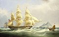
William John Huggins, East Indianman „Asia”, ok. 1831
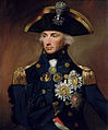
Lemuel Francis Abbott, Kontradmirał Horatio Nelson, 1799
Abraham Storck, Car Piotr I ogląda statek „Amsterdam”, ok. 1700
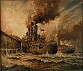
Charles John De Lacy, HMS „Vindictive” pod Zeebrugge 23 kwietnia 1918

Galion okrętu HMS „Implacable” w National Maritime Museum
Christiaan Julius Lodewyck Portman, Śmierć Wiliama Barentsa, 1836

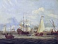
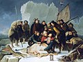
Nicholas Pocock, Bitwa u wybrzeży Santo Domingo, 1806


Uwagi
- ↑ Podobne kłopoty ma Muzeum Brytyjskie oskarżane o bezprawne posiadanie dzieł sztuki starożytnej Grecji, Egiptu i Mezopotamii.
Przypisy
- ↑ National Maritime Museum, Governing Acts of Parliament. nmm.ac.uk. [zarchiwizowane z tego adresu (2007-06-08)]..
- ↑ Michael Lewis, Callender, Sir Geoffrey Arthur Romaine (1875–1946), Oxford Dictionary of National Biography, Oxford University Press, 2004.
- ↑ a b Martin Baileya: Nazistowskie obrazy w muzeum zrabowane przez Brytyjczyków, The Art Newspaper z 3 stycznia 2007
Media użyte na tej stronie


Contains Ordnance Survey data © Crown copyright and database right, CC BY-SA 3.0
Blank map of the London Borough of Greenwich, showing electoral wards.
Equirectangular map projection on WGS 84 datum, with N/S stretched 160%
Geographic limits:
- West: 0.03W
- East: 0.13E
- North: 51.52N
- South: 51.42N

Autor: Rémi Kaupp, Licencja: CC-BY-SA-3.0
Model of a 20-gun ship, 6th rate, ca. 1719, with its oars in position. May represent a 5th rate rebuilt as a 6th rate like Blandford or Lyme.


Autor: Rémi Kaupp, Licencja: CC-BY-SA-3.0
Figurehead of the 74-gun ship Implacable, 1800, originally named Duguay Trouin by the French.
Contains Ordnance Survey data © Crown copyright and database right, CC BY-SA 3.0
Map of Greater London, UK with the following information shown:
- Administrative borders
- Coastline, lakes and rivers
- Roads and railways
- Urban areas
The data includes both primary routes and railway lines.
Equirectangular map projection on WGS 84 datum, with N/S stretched 160%
Geographic limits:
- West: 0.57W
- East: 0.37E
- North: 51.72N
- South: 51.25N
Autor: Katie Chan, Licencja: CC BY-SA 3.0
This is a photo of listed building number 1211481.

Following Nelson's victory at Trafalgar in 1805, Sir John Duckworth left the blockade of Cadiz and pursued a French squadron to the Caribbean, where he defeated it off San Domingo on the 6 February 1806. With six ships of the line and two frigates he was lying off St Kitts, watering and refitting his squadron, when he heard on that three French ships of the line were making for San Domingo. A force of nine French ships were found at anchor in San Domingo Roads, whence they slipped their cables and made sail in a westerly direction, forming a line of battle close inshore. The British closed in on them in two lines to cut them off.
(c) Karte: NordNordWest, Lizenz: Creative Commons by-sa-3.0 de
Location map of the United Kingdom