Naval Submarine Base New London
 | |
 | |
| Państwo | |
|---|---|
| Stan | |
| Miejscowość | Groton |
| Kod taktyczny | SUBASE NLON |
| Rodzaj bazy | Baza okrętów podwodnych |
| Historia | |
| Używana od | 13 października 1915 |
| Dane taktyczne | |
| Dowództwa | • Commander Navy Region Northeast (CNRNE) • Commander Submarine Group Two (CSG2) • Naval Submarine School (NAVSUBSCOL) |
| Personel bazy | 21.000 (w tym członkowie rodzin) |
| Instalacje | Stocznia Electric Boat |
| Stacjonujące jednostki | • Submarine Group Two • Submarine Squadron Two • Submarine Squadron Four • Submarine Development Squadron • Regional Support Group • Naval Submarine Support |
| Bazująca broń | • 14 okrętów typu 688 • 5 okrętów typu 774 |
| Użytkownicy | |
| Stany Zjednoczone | |
| 41°23′53″N 72°05′13″W/41,398115 -72,086964 | |
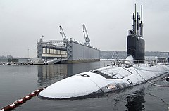
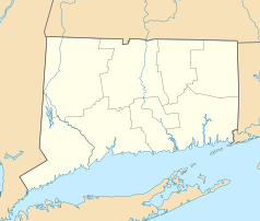
Naval Submarine Base New London (SUBASE NLON) — baza morska okrętów podwodnych marynarki wojennej Stanów Zjednoczonych, stanowiąca część kompleksu US Navy w Groton, Connecticut w hrabstwie New London.
Baza okrętów podwodnych New London w Groton jest najstarszą, historycznie pierwszą baza tego typu jednostek w Stanach Zjednoczonych, "Home of the Submarine Force". Obecnie jest portem macierzystym dla 17 myśliwskich okrętów podwodnych "fast attack submarine" typu Los Angeles oraz Virginia.
Wraz z sąsiednią stocznią Marynarki Wojennej General Dynamics Electric Boat w Groton, jest też jednym z największych centrów US Navy.
Linki zewnętrzne
Witryna oficjalna bazy Naval Submarine Base New London (ang.)
Media użyte na tej stronie
Autor: Uwe Dedering, Licencja: CC BY-SA 3.0
Location map of the USA (without Hawaii and Alaska).
EquiDistantConicProjection:
Central parallel:
* N: 37.0° N
Central meridian:
* E: 96.0° W
Standard parallels:
* 1: 32.0° N
* 2: 42.0° N
Made with Natural Earth. Free vector and raster map data @ naturalearthdata.com.
Formulas for x and y:
x = 50.0 + 124.03149777329222 * ((1.9694462586094064-({{{2}}}* pi / 180))
      * sin(0.6010514667026994 * ({{{3}}} + 96) * pi / 180))
y = 50.0 + 1.6155950752393982 * 124.03149777329222 * 0.02613325650382181
      - 1.6155950752393982  * 124.03149777329222 *
     (1.3236744353715044  - (1.9694462586094064-({{{2}}}* pi / 180))
      * cos(0.6010514667026994 * ({{{3}}} + 96) * pi / 180))
The flag of Navassa Island is simply the United States flag. It does not have a "local" flag or "unofficial" flag; it is an uninhabited island. The version with a profile view was based on Flags of the World and as a fictional design has no status warranting a place on any Wiki. It was made up by a random person with no connection to the island, it has never flown on the island, and it has never received any sort of recognition or validation by any authority. The person quoted on that page has no authority to bestow a flag, "unofficial" or otherwise, on the island.
Autor: Alexrk2, Licencja: CC BY 3.0
Ta mapa została stworzona za pomocą GeoTools.
Patch of the U.S. Naval Submarine Base New London, Connecticut (USA).
Snow covers the hull of the fast attack submarine USS Virginia (SSN 774) as it sits moored to the pier at Naval Submarine Base New London in Groton, Conn., on Feb. 2, 2007.


