Ndola
| ||
 | ||
| Państwo | ||
| Prowincja | Prowincja Pasa Miedzionośnego | |
| Wysokość | 1300 m n.p.m. | |
| Populacja (2012) • liczba ludności | 517 975 | |
| Nr kierunkowy | 02 | |
| Strona internetowa | ||
Ndola – miasto w Zambii, ośrodek administracyjny prowincji Copperbelt. Około 495,9 tys. mieszkańców. Miasto założono w 1902 r.
W mieście znajduje się duży ośrodek wydobycia rud miedzi oraz uranu. Dobrze rozwinięty przemysł metalurgiczny, maszynowy, metalowy, materiałów budowlanych, chemiczny, drzewny oraz spożywczy. Trzecie co do wielkości miasto kraju.
Miasta partnerskie
Linki zewnętrzne
- Ndola na World-gazetteer.com
Media użyte na tej stronie
Flag of Portugal, created by Columbano Bordalo Pinheiro (1857-1929), officially adopted by Portuguese government in June 30th 1911 (in use since about November 1910). Color shades matching the RGB values officially reccomended here. (PMS values should be used for direct ink or textile; CMYK for 4-color offset printing on paper; this is an image for screen display, RGB should be used.)
The national flag of the Democratic Republic of the Congo. Created according to the 2006 constitution : Son emblème est le drapeau bleu ciel, orné d’une étoile jaune dans le coin supérieur gauche et traversé en biais d’une bande rouge finement encadrée de jaune. (Its symbol is a sky blue flag, decorated with a yellow star in the upper left corner and crossed in the diagonal by a red strip with thin yellow borders) It seems to be identical, except for a lighter field hue, to the 1966–1971 flag.
Flag of Namibia
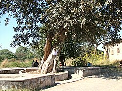
The Slave Tree in Ndola


