Neck Road
 | |
| Państwo | |
|---|---|
| Data otwarcia | 23 sierpnia 1907 |
| B Q | |
| Poprzednia stacja | |
| Następna stacja | Sheepshead Bay |
Położenie na mapie Nowego Jorku  | |
Położenie na mapie Stanów Zjednoczonych  | |
Położenie na mapie stanu Nowy Jork  (c) NordNordWest, CC BY 3.0 | |
| Portal | |
Neck Road – stacja metra nowojorskiego, na linii B i Q. Znajduje się w dzielnicy Brooklyn, w Nowym Jorku i zlokalizowana jest pomiędzy stacjami Avenue U i Sheepshead Bay. Została otwarta 23 sierpnia 1907[1].
Przypisy
- ↑ New York City, urbanrail.net (ang.)
Linki zewnętrzne
- Sieć metra. mta.info. [dostęp 2011-04-02]. (ang.).

Schody prowadzące na platformę w kierunku południowym
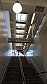
Clerestory na schodach
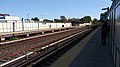
Patrząc na północ na peron

Śledź na północ od stacji
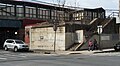
Stacja ta była używana przez nieistniejący oddział LIRR Manhattan Beach.
|
![]()
![]()
![]()
![]()
Media użyte na tej stronie
Usa edcp location map.svg
Autor: Uwe Dedering, Licencja: CC BY-SA 3.0
Location map of the USA (without Hawaii and Alaska).
Autor: Uwe Dedering, Licencja: CC BY-SA 3.0
Location map of the USA (without Hawaii and Alaska).
EquiDistantConicProjection:
Central parallel:
* N: 37.0° N
Central meridian:
* E: 96.0° W
Standard parallels:
* 1: 32.0° N
* 2: 42.0° N
Made with Natural Earth. Free vector and raster map data @ naturalearthdata.com.
Formulas for x and y:
x = 50.0 + 124.03149777329222 * ((1.9694462586094064-({{{2}}}* pi / 180))
      * sin(0.6010514667026994 * ({{{3}}} + 96) * pi / 180))
y = 50.0 + 1.6155950752393982 * 124.03149777329222 * 0.02613325650382181
      - 1.6155950752393982  * 124.03149777329222 *
     (1.3236744353715044  - (1.9694462586094064-({{{2}}}* pi / 180))
      * cos(0.6010514667026994 * ({{{3}}} + 96) * pi / 180))
USA New York location map.svg
(c) NordNordWest, CC BY 3.0
Location map of the State of New York, USA
(c) NordNordWest, CC BY 3.0
Location map of the State of New York, USA

Flag of the United States.svg
The flag of Navassa Island is simply the United States flag. It does not have a "local" flag or "unofficial" flag; it is an uninhabited island. The version with a profile view was based on Flags of the World and as a fictional design has no status warranting a place on any Wiki. It was made up by a random person with no connection to the island, it has never flown on the island, and it has never received any sort of recognition or validation by any authority. The person quoted on that page has no authority to bestow a flag, "unofficial" or otherwise, on the island.
The flag of Navassa Island is simply the United States flag. It does not have a "local" flag or "unofficial" flag; it is an uninhabited island. The version with a profile view was based on Flags of the World and as a fictional design has no status warranting a place on any Wiki. It was made up by a random person with no connection to the island, it has never flown on the island, and it has never received any sort of recognition or validation by any authority. The person quoted on that page has no authority to bestow a flag, "unofficial" or otherwise, on the island.

NYC Subway BMT Brighton LIne Neck Road - Looking northeast.jpg
Autor: GK tramrunner RU, Licencja: CC BY-SA 4.0
NYC Subway BMT Brighton LIne Neck Road - Looking northeast
Autor: GK tramrunner RU, Licencja: CC BY-SA 4.0
NYC Subway BMT Brighton LIne Neck Road - Looking northeast

NYC Subway BMT Brighton LIne Neck Road - southbound entrance.jpg
Autor: GK tramrunner RU, Licencja: CC BY-SA 4.0
NYC Subway BMT Brighton LIne Neck Road - stair to the southbound platform.
Autor: GK tramrunner RU, Licencja: CC BY-SA 4.0
NYC Subway BMT Brighton LIne Neck Road - stair to the southbound platform.

NYC Subway BMT Brighton LIne Neck Road - stair and ceiling.jpg
Autor: GK tramrunner RU, Licencja: CC BY-SA 4.0
NYC Subway BMT Brighton LIne Neck Road - staircase and ceiling
Autor: GK tramrunner RU, Licencja: CC BY-SA 4.0
NYC Subway BMT Brighton LIne Neck Road - staircase and ceiling

NYC Subway BMT Brighton LIne Neck Road - looking on northbound platform.jpg
Autor: GK tramrunner RU, Licencja: CC BY-SA 4.0
NYC Subway BMT Brighton LIne Neck Road - looking on northbound platform
Autor: GK tramrunner RU, Licencja: CC BY-SA 4.0
NYC Subway BMT Brighton LIne Neck Road - looking on northbound platform
NYCS-bull-trans-Q.svg
Bullet for New York City Subway Q service used from 2001-present.
Bullet for New York City Subway Q service used from 2001-present.
USA New York City location map.svg
Autor: Alexrk2, Licencja: CC BY 3.0
Ta mapa została stworzona za pomocą GeoTools.
Autor: Alexrk2, Licencja: CC BY 3.0
Ta mapa została stworzona za pomocą GeoTools.
NYCS-bull-trans-B.svg
Bullet for New York City Subway B service
Bullet for New York City Subway B service

NYC Subway Gravesend Neck Road Station.jpg
Autor: GK tramrunner RU, Licencja: CC BY-SA 4.0
NYC Subway Gravesend Neck Road Station, remaining wall from dismantled LIRR line next to it.
Autor: GK tramrunner RU, Licencja: CC BY-SA 4.0
NYC Subway Gravesend Neck Road Station, remaining wall from dismantled LIRR line next to it.
Neck Road Station Entrance.jpg
Station entrance to Neck Road
Station entrance to Neck Road