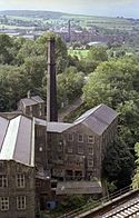
New Mills
(c) Dave Bevis, CC BY-SA 2.0 | |
| Państwo | |
|---|---|
| Kraj | |
| Hrabstwo | |
| Dystrykt | |
| Populacja • liczba ludności |
|
| Nr kierunkowy | 01663 |
| Kod pocztowy | SK22 |
Położenie na mapie Derbyshire Contains Ordnance Survey data © Crown copyright and database right, CC BY-SA 3.0 | |
Położenie na mapie Wielkiej Brytanii (c) Karte: NordNordWest, Lizenz: Creative Commons by-sa-3.0 de | |
| Strona internetowa | |
| Portal | |
New Mills – miasto w Anglii, w hrabstwie Derbyshire, w dystrykcie High Peak. Leży 61 km na północny zachód od miasta Derby i 243 km na północny zachód od Londynu[1]. Miasto liczy 9625 mieszkańców.
W New Mills siedzibę ma Swizzels Matlow, jedna z największych firm w branży cukierniczej.
Przypisy
- ↑ New Mills na mapie (ang.). getamap.ordnancesurvey.co.uk. [dostęp 2010-10-06].
Media użyte na tej stronie
Contains Ordnance Survey data © Crown copyright and database right, CC BY-SA 3.0
Map of Derbyshire, UK with the following information shown:
- Administrative borders
- Coastline, lakes and rivers
- Roads and railways
- Urban areas
Equirectangular map projection on WGS 84 datum, with N/S stretched 165%
Geographic limits:
- West: 2.06W
- East: 1.10W
- North: 53.55N
- South: 52.69N
(c) Karte: NordNordWest, Lizenz: Creative Commons by-sa-3.0 de
Location map of the United Kingdom
Flag of England. Saint George's cross (a red cross on a white background), used as the Flag of England, the Italian city of Genoa and various other places.
(c) Dave Bevis, CC BY-SA 2.0
New Mills - Torr Vale Mill This photo was taken in 1982 when the mill was still in use. The vandals and arsonists have since taken over. The large building in the background (in Newtown) is the Swizzel's factory.


