New York (Tyne and Wear)
| Ten artykuł od 2011-11 wymaga zweryfikowania podanych informacji. |
| ||
(c) Ken Brown, CC BY-SA 2.0 | ||
| Państwo | ||
| Kraj | ||
| Hrabstwo ceremonialne | Tyne and Wear | |
| Unitary authority | North Tyneside | |
| Nr kierunkowy | 0191 | |
| Kod pocztowy | NE29 | |
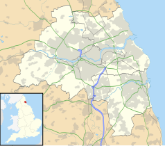
Położenie na mapie Tyne and Wear Contains Ordnance Survey data © Crown copyright and database right, CC BY-SA 3.0 | ||
Położenie na mapie Wielkiej Brytanii (c) Karte: NordNordWest, Lizenz: Creative Commons by-sa-3.0 de | ||
| Portal | ||
New York – wieś w Anglii, w hrabstwie ceremonialnym Tyne and Wear, w dystrykcie (unitary authority) North Tyneside.
Media użyte na tej stronie
(c) Karte: NordNordWest, Lizenz: Creative Commons by-sa-3.0 de
Location map of the United Kingdom
Flag of England. Saint George's cross (a red cross on a white background), used as the Flag of England, the Italian city of Genoa and various other places.
Contains Ordnance Survey data © Crown copyright and database right, CC BY-SA 3.0
Map of Tyne and Wear, UK, with the following information shown:
- Administrative borders
- Coastline, lakes and rivers
- Roads and railways
- Urban areas
Equirectangular map projection on WGS 84 datum, with N/S stretched 170%
Geographic limits:
- West: 1.90W
- East: 1.30W
- North: 55.09N
- South: 54.78N
(c) Ken Brown, CC BY-SA 2.0
Silverlink Park Sundial. In 1996 work started on reclaiming the West Allotment Tip and the remains of the spoil heap from the former Backworth Colliery. The large mound at the centre of the park is the highest ground in North Tyneside. It provides panoramic views of the area and is topped by the Silverlink Sundial.


