Newcastle Central
| ||
 | ||
| Państwo | ||
| Kraj | ||
| Miejscowość | Newcastle upon Tyne | |
| Data otwarcia | 1850 | |
| Dane techniczne | ||
| Liczba peronów | 5 | |
| Liczba krawędzi peronowych | 10 | |
| Kasy | ||
| Linie kolejowe | ||
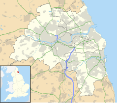
Położenie na mapie Tyne and Wear Contains Ordnance Survey data © Crown copyright and database right, CC BY-SA 3.0 | ||
Położenie na mapie Wielkiej Brytanii (c) Karte: NordNordWest, Lizenz: Creative Commons by-sa-3.0 de | ||
| Portal | ||
Newcastle Central – stacja kolejowa w Newcastle upon Tyne, w Anglii. Posiada 5 peronów i obsługuje 4,870 mln pasażerów rocznie.
Przewoźnikiem zarządzającym stacją jest East Coast[1], a obsługują ją również First ScotRail, Northern Rail, CrossCountry oraz First TransPennine Express.
Przypisy
- ↑ National Rail Enquiries - Station Facilities for Newcastle. [dostęp 2010-12-17].
Media użyte na tej stronie
(c) Karte: NordNordWest, Lizenz: Creative Commons by-sa-3.0 de
Location map of the United Kingdom
Flag of England. Saint George's cross (a red cross on a white background), used as the Flag of England, the Italian city of Genoa and various other places.
Autor: MGalloway (WMF), Licencja: CC BY-SA 3.0
A tickmark icon included in the OOjs UI MediaWiki lib.
Autor: MGalloway (WMF), Licencja: CC BY-SA 3.0
A tickmark icon included in the OOjs UI MediaWiki lib.
Autor: Brendadada, Licencja: CC BY-SA 2.0
The northern end of Newcastle central railway station.
Contains Ordnance Survey data © Crown copyright and database right, CC BY-SA 3.0
Map of Tyne and Wear, UK, with the following information shown:
- Administrative borders
- Coastline, lakes and rivers
- Roads and railways
- Urban areas
Equirectangular map projection on WGS 84 datum, with N/S stretched 170%
Geographic limits:
- West: 1.90W
- East: 1.30W
- North: 55.09N
- South: 54.78N


