Newport (hrabstwo miejskie)
| hrabstwo miejskie | |||
 Newport | |||
| |||
| Państwo | |||
|---|---|---|---|
| Księstwo | |||
| Siedziba | |||
| Powierzchnia | 190 km² | ||
| Wysokość | 0–30 m n.p.m. | ||
| Populacja (2011) • liczba ludności |
| ||
| • gęstość | 1997 os./km² | ||
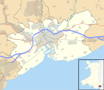
Położenie na mapie Walii | |||
| Strona internetowa | |||
| Portal | |||
Newport – hrabstwo miejskie w południowo-wschodniej Walii, obejmujące miasto Newport i okolice. W 2011 roku hrabstwo liczyło 145 736 mieszkańców[1][2].
Ludność
Większość (71,9%) ludności Newport jest chrześcijanami, zaś 2,6% to muzułmanie. Znajduje się tu 7 meczetów i 50 kościołów.
Podział administracyjny
Communities (civil parishes)
- Allt-yr-Yn, Alway, Beechwood, Bettws, Bishton, Caerleon, Coedkernew, Gaer, Goldcliff, Graig, Langstone, Liswerry, Llanvaches, Llanwern, Malpas, Marshfield, Michaelstone-y-Fedw, Nash, Penhow, Pillgwenlly, Redwick, Ringland, Rogerstone, Shaftesbury, St. Julians, Stow Hill, Tredegar Park, Victoria i Wentlooge.
Okręgi wyborcze (wards)
- Allt-yr-Yn, Alway, Beechwood, Bettws, Caerleon, Gaer, Graig, Langstone, Llanwern, Liswerry, Malpas, Marshfield, Pillgwenlly, Ringland, Rogerstone, Shaftesbury, St. Julians, Stow Hill, Tredegar Park i Victoria[3].
Miejscowości
Na terenie hrabstwa znajdują się następujące miejscowości[4][5] (w nawiasach liczba ludności w 2011[6]):
Mapa
Przypisy
- ↑ Area: Newport (Local Authority). Neighbourhood Statistics (ONS). [dostęp 2016-10-30]. [zarchiwizowane z tego adresu (2016-10-30)]. (ang.).
- ↑ Newport, [w:] Encyclopædia Britannica [online] [dostęp 2016-10-30] (ang.).
- ↑ Casnewydd - Newport. Ordnance Survey linked data. [dostęp 2016-10-30]. (ang.).
- ↑ Office for National Statistics: Built-up Area to Local Authority District (December 2011) Lookup in England and Wales. [w:] Open Geography Portal [on-line]. [dostęp 2022-06-05]. (ang.).
- ↑ Office for National Statistics: Built-up Area Sub Divisions (December 2011) Boundaries. [w:] Open Geography Potal [on-line]. [dostęp 2022-06-05]. (ang.).
- ↑ Office for National Statistics: KS101EW - Usual resident population. [w:] 2011 Census [on-line]. Nomis – Official labour market statistics, 2013-02-12. [dostęp 2022-06-05]. (ang.).
Media użyte na tej stronie
Autor: Owain, Licencja: CC BY-SA 3.0
Montage of Newport, Monmouthshire: Newport Transporter Bridge, Tredegar House, Newport Castle, Newport Cathedral, Celtic Manor Resort, Newport Civic Centre and skyline from Brynglas Hill.
Contains Ordnance Survey data © Crown copyright and database right, CC BY-SA 3.0
Blank map of Newport, UK with the following information shown:
- Administrative borders
- Coastline, lakes and rivers
- Roads and railways
- Urban areas
Equirectangular map projection on WGS 84 datum, with N/S stretched 160%
Geographic limits:
- West: 3.15W
- East: 2.78W
- North: 51.67N
- South: 51.47N
Autor: TUBS
Location of unitary authority area Newport in Wales in Wales.


