Norfolk (Wielka Brytania)
| Hrabstwo ceremonialne i niemetropolitalne | |||||
(c) Christine Matthews, CC BY-SA 2.0 Plaża w Cromer | |||||
| |||||
| Państwo | |||||
|---|---|---|---|---|---|
| Kraj | |||||
| Region | |||||
| Siedziba | |||||
| Powierzchnia | 5371 km² | ||||
| Populacja (2011) • liczba ludności |
| ||||
| • gęstość | 159,7 os./km² | ||||
| Szczegółowy podział administracyjny | |||||
 | |||||
| Liczba dystryktów | 7 | ||||
Położenie na mapie | |||||
| Strona internetowa | |||||
| Portal | |||||
Norfolk – hrabstwo administracyjne (niemetropolitalne), ceremonialne i historyczne we wschodniej Anglii, w regionie East of England, położone nad Morzem Północnym i zatoką The Wash, na obszarze krainy geograficzno-historycznej zwanej Anglią Wschodnią (East Anglia).
Powierzchnia hrabstwa wynosi 5371 km² a liczba mieszkańców – 857 900[1]. Ośrodkiem administracyjnym Norfolku, największym miastem a zarazem jedynym miastem o statusie city, jest Norwich. Innymi większymi miastami na terenie hrabstwa są Great Yarmouth, King’s Lynn, Thetford, Gorleston-on-Sea oraz Dereham[2].
Norfolk jest hrabstwem nizinnym. Znaczna część północnego wybrzeża, Norfolk Coast, objęta jest ochroną jako obszar o wybitnym pięknie naturalnym (Area of Outstanding Natural Beauty), a gęsta sieć żeglownych rzek i jezior na wschodzie hrabstwa – The Broads – posiada status zbliżony do parku narodowego.
Hrabstwo ma w przeważającej części charakter wiejski. Ważną rolę w gospodarce odgrywa rolnictwo, przemysł lekki oraz, zwłaszcza na wybrzeżu, turystyka.
Na południu Norfolk graniczy z hrabstwem Suffolk, na zachodzie z Cambridgeshire, a na północnym zachodzie z Lincolnshire.
Podział administracyjny
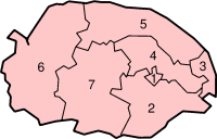
W skład hrabstwa wchodzi siedem dystryktów.
Mapa
Przypisy
- ↑ Table P04 2011 Census: Usual resident population by five-year age group, local authorities in England and Wales. Office for National Statistics. [dostęp 2012-07-18]. (ang.).
- ↑ a b Office for National Statistics: KS101EW - Usual resident population. [w:] 2011 Census [on-line]. Nomis – Official labour market statistics, 2013-02-12. [dostęp 2022-06-05]. (ang.).
- ↑ Office for National Statistics: Built-up Area to Local Authority District (December 2011) Lookup in England and Wales. [w:] Open Geography Portal [on-line]. [dostęp 2022-06-05]. (ang.).
- ↑ Office for National Statistics: Built-up Area Sub Divisions (December 2011) Boundaries. [w:] Open Geography Potal [on-line]. [dostęp 2022-06-05]. (ang.).
Bibliografia
- Norfolk, [w:] Encyclopædia Britannica [online] [dostęp 2012-06-17] (ang.).
Media użyte na tej stronie
Flag of England. Saint George's cross (a red cross on a white background), used as the Flag of England, the Italian city of Genoa and various other places.
Contains Ordnance Survey data © Crown copyright and database right, CC BY-SA 3.0
Map of Norfolk, UK with the following information shown:
- Administrative borders
- Coastline, lakes and rivers
- Roads and railways
- Urban areas
Equirectangular map projection on WGS 84 datum, with N/S stretched 160%
Geographic limits:
- West: 0.12E
- East: 2.00E
- North: 53.05N
- South: 52.32N
Autor: Nilfanion, Licencja: CC BY-SA 3.0
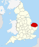
Location of the ceremonial county of Norfolk within England.
(c) Christine Matthews, CC BY-SA 2.0
Cromer Sunrise Note the two photographers on the promenade with tripods waiting for the light.
Coat of arms of Norfolk, England (United Kingdom).
Blazon:
- Arms
- Per pale Or and Sable a Bend Ermine on a Chief Gules a Lion passant guardant of the first between two Ostrich Plumes Argent quilled and each ensigned with a Prince's Coronet thereon the motto "Ich Dien" as borne on the Banner of King Edward III.
- Supporters
- On either side a Lion guardant Or that on the sinister dimidiating a Herring erect Argent.


