North Charleston
| ||||
| ||||
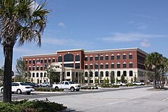
 Ratusz Miejski w North Charleston | ||||
| ||||
| Państwo | ||||
| Stan | ||||
| Hrabstwo | Berkeley, Charleston, Dorchester[1] | |||
| Data założenia | 12 czerwca 1972 | |||
| Kod statystyczny | FIPS: 45-50875 GNIS ID: 1225072 | |||
| Burmistrz | R. Keith Summey[2] | |||
| Powierzchnia | 198,4 km² | |||
| Wysokość | 6[3] - 13 [4] m n.p.m. | |||
| Populacja (2010) • liczba ludności • gęstość | 97 471 491,3 os./km² | |||
| Nr kierunkowy | 843 | |||
| Strefa czasowa | UTC-05:00 UTC-04:00 | |||
| Strona internetowa | ||||
| Portal | ||||
North Charleston – miasto położone na terytorium hrabst Berkeley, Charleston, Dorchester[1], w stanie Karolina Południowa, USA, nad rzekami Cooper River i Ashley River. North Charleston wchodzi w skład obszaru metropolitalnego Charleston–North Charleston–Summerville.
Według spisu z 2010 r. 97 471 mieszkańców. Jest trzecim pod względem liczby ludności miastem w stanie.
Historia
Pierwsze wzmianki o osadnictwie sięgają XVII wieku i dotyczą przede wszystkim zakładanych na tych terenach plantacji.
Na początku XX wieku w rejonie pojawił się pierwszy przemysł. W 1901 roku założono Stocznię Marynarki Wojennej w Charleston.
12 czerwca 1972 roku Sąd Najwyższy Stanu Karolina Południowa podtrzymał wyniki referendum i North Charleston stała się miastem (dziewiątym pod względem ilości ludności w stanie).
Przemysł
W mieście znajduje się między innymi Stocznia Marynarki Wojennej w Charleston, jedna z linii montażowych firmy Boeing, fabryka Daimler AG oraz call center operatora telefonii komórkowej Verizon.
Zobacz też
- Port lotniczy Charleston
- North Charleston Coliseum
Przypisy
| ||||||||||
Media użyte na tej stronie
Autor: Alexrk, Licencja: CC BY 3.0
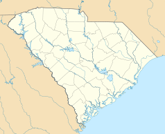
Ta mapa została stworzona za pomocą GeoTools.
Autor: Uwe Dedering, Licencja: CC BY-SA 3.0
Location map of the USA (without Hawaii and Alaska).
EquiDistantConicProjection:
Central parallel:
* N: 37.0° N
Central meridian:
* E: 96.0° W
Standard parallels:
* 1: 32.0° N
* 2: 42.0° N
Made with Natural Earth. Free vector and raster map data @ naturalearthdata.com.
Formulas for x and y:
x = 50.0 + 124.03149777329222 * ((1.9694462586094064-({{{2}}}* pi / 180))
      * sin(0.6010514667026994 * ({{{3}}} + 96) * pi / 180))
y = 50.0 + 1.6155950752393982 * 124.03149777329222 * 0.02613325650382181
      - 1.6155950752393982  * 124.03149777329222 *
     (1.3236744353715044  - (1.9694462586094064-({{{2}}}* pi / 180))
      * cos(0.6010514667026994 * ({{{3}}} + 96) * pi / 180))
The flag of Navassa Island is simply the United States flag. It does not have a "local" flag or "unofficial" flag; it is an uninhabited island. The version with a profile view was based on Flags of the World and as a fictional design has no status warranting a place on any Wiki. It was made up by a random person with no connection to the island, it has never flown on the island, and it has never received any sort of recognition or validation by any authority. The person quoted on that page has no authority to bestow a flag, "unofficial" or otherwise, on the island.
The new City Of North Charleston City Hall.
- It opened in 2009.
Autor: City of North Charleston, Licencja: CC BY-SA 3.0
The flag of the city of North Charleston, SC.


