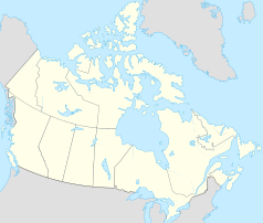
Northeastern Manitoulin and the Islands
 | |
| Państwo | |
|---|---|
| Prowincja | |
| Burmistrz | Jim Stringer |
| Powierzchnia | 495,04 km² |
| Populacja (2006) • liczba ludności • gęstość |
|
| Strona internetowa | |
| Portal | |
Northeastern Manitoulin and the Islands – gmina o statusie miejskim w Kanadzie, w prowincji Ontario, w dystrykcie Manitoulin. Położona jest na wyspie Manitoulin, która leży na jeziorze Huron. Powstała w 1998 roku poprzez połączenie miasta Little Current, kantonu Howland i szeregu małych wysp, otaczających wyspę Manitoulin (łącznie z tymi u jej zachodniego krańca).
Liczba mieszkańców Northeastern Manitoulin and the Islands wynosi 2 711. Język angielski jest językiem ojczystym dla 90,3%, francuski dla 3,4% mieszkańców (2006)[1].
Przypisy
Media użyte na tej stronie
Autor: NordNordWest, Licencja: CC BY-SA 3.0
Location map of Ontario, Canada
Autor: Yug, Licencja: CC-BY-SA-3.0
cropped version of Carte administrative du Canada.svg for map location.
Autor: P199, Licencja: CC BY-SA 2.5
Little Current, Manitoulin Island, Ontario, Canada
Flag of Ontario.


