Northolt (stacja metra)
| Państwo | |
|---|---|
| Miejscowość | Londyn |
| Dzielnica | Northolt |
| Data otwarcia | 1948 |
| Liczba peronów | 2 |
| Central Line | |
| Poprzednia stacja | South Ruislip |
| Następna stacja | Greenford |
Położenie na mapie gminy Ealing  Contains Ordnance Survey data © Crown copyright and database right, CC BY-SA 3.0 | |
Położenie na mapie Wielkiej Brytanii  (c) Karte: NordNordWest, Lizenz: Creative Commons by-sa-3.0 de | |
Położenie na mapie Anglii  | |
Położenie na mapie Wielkiego Londynu  Contains Ordnance Survey data © Crown copyright and database right, CC BY-SA 3.0 | |
| Portal | |
Northolt – stacja londyńskiego metra położona na trasie Central Line pomiędzy stacjami South Ruislip i Greenford. Stacja mieści się w piątej strefie biletowej, w dzielnicy Ealing, w zachodniej części miasta[1].
Stacja została otwarta przez Great Western Railway w 1907 jako Northolt Halt i stanowiła część połączenia New North Main Line do Birmingham. Została jednak zamknięta w 1948, kiedy to Central Line rozbudowywała połączenia z North Acton. Obecna stacja została otwarta 21 listopada 1948 roku. Początkowo otwarcie było planowane na lata 30. XX wieku, ale zostało opóźnione przez wybuch II wojny światowej[2].
Połączenia
Stację obsługują autobusy linii 90, 120, 140, 282, 395 i E10, a także nocna N7.
Galeria

Widok na zachód
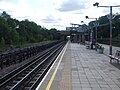
Widok na wschód
Symbol stacji
Przypisy
- ↑ Tube stations - Northolt (ang.). Transport for London. [dostęp 2012-01-05].
- ↑ Central Line, Dates (ang.). Clive's Underground Line Guides. [dostęp 2012-01-08].
| Linia główna | |
|---|---|
| Odgałęzienie West Ruislip | |
| Odgałęzienie Ealing Broadway | |
| Odgałęzienie Woodford | |
| Odgałęzienie Epping |
![]()
Media użyte na tej stronie
(c) Karte: NordNordWest, Lizenz: Creative Commons by-sa-3.0 de
Location map of the United Kingdom
Contains Ordnance Survey data © Crown copyright and database right, CC BY-SA 3.0
Map of Greater London, UK with the following information shown:
- Administrative borders
- Coastline, lakes and rivers
- Roads and railways
- Urban areas
The data includes both primary routes and railway lines.
Equirectangular map projection on WGS 84 datum, with N/S stretched 160%
Geographic limits:
- West: 0.57W
- East: 0.37E
- North: 51.72N
- South: 51.25N


Contains Ordnance Survey data © Crown copyright and database right, CC BY-SA 3.0
Blank map of the London Borough of Ealing, showing electoral wards used from 2002 to 2022.
Equirectangular map projection on WGS 84 datum, with N/S stretched 160%
Geographic limits:
- West: 0.425W
- East: 0.24W
- North: 51.565N
- South: 51.485N

(c) Sunil060902 z angielskiej Wikipedii, CC BY-SA 3.0
Northolt tube station on Mandeville Road

(c) Sunil060902 z angielskiej Wikipedii, CC BY-SA 3.0
Roundel on Northolt tube station westbound platform face

Autor: Sunil060902, Licencja: CC BY-SA 3.0
Northolt tube station island platform looking eastbound, with the rarely used former GWR route on the extreme left, reduced to single track here.

Autor: Sunil060902, Licencja: CC BY-SA 3.0
Northolt tube station island platform looking west, with rarely used former GWR route on extreme right, reduced to single track. There is a reversing siding for the Central line just to the west of the station.