Nuncjatura Apostolska w Wielkiej Brytanii
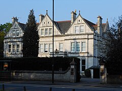
(c) Andrew Wilson, CC BY-SA 2.0 Budynek nuncjatury w Londynie | |
| Państwo | |
|---|---|
| Data utworzenia | 1938 |
| Nuncjusz apostolski | vacat |
| Adres | |
| 54 Parkside, Wimbledon, London SW19 5NE | |
Położenie na mapie gminy Merton Contains Ordnance Survey data © Crown copyright and database right, CC BY-SA 3.0 | |
Położenie na mapie Wielkiej Brytanii (c) Karte: NordNordWest, Lizenz: Creative Commons by-sa-3.0 de | |
Położenie na mapie Wielkiego Londynu Contains Ordnance Survey data © Crown copyright and database right, CC BY-SA 3.0 | |
| 51°26′09,96″N 0°13′26,04″W/51,436100 -0,223900 | |
Nuncjatura Apostolska w Wielkiej Brytanii – misja dyplomatyczna Stolicy Apostolskiej w Wielkiej Brytanii. Siedziba nuncjusza apostolskiego mieści się w Londynie.
Historia
Delegaturę Apostolską w Wielkiej Brytanii utworzył papież Pius XI w 1938. Jan Paweł II w 1982 promował ją do rangi nuncjatury apostolskiej.
Szefowie przedstawicielstwa Stolicy Apostolskiej w Wielkiej Brytanii
Delegaci apostolscy
- abp William Godfrey (1938–1953) Brytyjczyk
- abp Gerald Patrick Aloysius O’Hara (1954–1963) Amerykanin
- abp Igino Eugenio Cardinale (1963– 1969) Włoch
- abp Domenico Enrici (1969–1973) Włoch
- abp Bruno Bernard Heim (1973–1982) Szwajcar
Pronuncjusze apostolscy
- abp Bruno Bernard Heim (1982–1985) Szwajcar
- abp Luigi Barbarito (1986–1993) Włoch
Nuncjusze apostolscy
- abp Luigi Barbarito (1993–1997) Włoch
- abp Pablo Puente Buces (1997–2004) Hiszpan
- abp Faustino Sainz Muñoz (2004–2010) Hiszpan
- abp Antonio Mennini (2010–2017) Włoch
- abp Edward Adams (2017–2020) Amerykanin
- abp Claudio Gugerotti (2020-2022) Włoch
Bibliografia
Media użyte na tej stronie
(c) Karte: NordNordWest, Lizenz: Creative Commons by-sa-3.0 de
Location map of the United Kingdom
Contains Ordnance Survey data © Crown copyright and database right, CC BY-SA 3.0
Map of Greater London, UK with the following information shown:
- Administrative borders
- Coastline, lakes and rivers
- Roads and railways
- Urban areas
The data includes both primary routes and railway lines.
Equirectangular map projection on WGS 84 datum, with N/S stretched 160%
Geographic limits:
- West: 0.57W
- East: 0.37E
- North: 51.72N
- South: 51.25N
(c) Andrew Wilson, CC BY-SA 2.0
This is a photo of listed building number 1080911.
Contains Ordnance Survey data © Crown copyright and database right, CC BY-SA 3.0
Blank map of the London Borough of Merton, showing electoral wards.
Equirectangular map projection on WGS 84 datum, with N/S stretched 160%
Geographic limits:
- West: 0.26W
- East: 0.12W
- North: 51.445N
- South: 51.375N


