Nykvarn
 Nykvarn | |
| Państwo | |
|---|---|
| Region | |
| Gmina | Nykvarn |
| Powierzchnia | 5,72[1] km² |
| Populacja (2018) • liczba ludności • gęstość | 7739[1] 1353[1] os./km² |
| Nr kierunkowy | (+46) 08 |
| Kod pocztowy | 155 xx |
| Strona internetowa | |
| Portal | |
Nykvarn – miejscowość (tätort) w Szwecji, w regionie administracyjnym (län) Sztokholm. Siedziba władz (centralort) gminy Nykvarn.
W 2015 roku Nykvarn liczyło 7327 mieszkańców[2].
Położenie
Położona w prowincji historycznej (landskap) Södermanland, ok. 15 km na zachód od Södertälje, na południe od autostrady E20. Przez Nykvarn przebiega linia kolejowa Svealandsbanan (Södertälje – Eskilstuna – Valskog).
Historia
W latach 1971–1998 Nykvarn należało administracyjnie do gminy Södertälje. 25 maja 1997 roku w Nykvarn i jego najbliższych okolicach przeprowadzono referendum w sprawie odłączenia się od gminy Södertälje i utworzenia własnej gminy. W wyniku referendum, a następnie zgody rządu Szwecji na podział gminy Södertälje, 1 stycznia 1999 roku utworzono gminę Nykvarn[3].
Demografia
Liczba ludności tätortu Nykvarn w latach 1960–2015[4]:
Przypisy
- ↑ a b c Statistiska tätorter 2018; befolkning, landareal, befolkningstäthet (szw.). Statistikmyndigheten SCB, 2020-03-20. [dostęp 2020-09-08]. [zarchiwizowane z tego adresu (2020-03-24)].
- ↑ Statistiska centralbyrån: Tätorter 2015; befolkning, landareal, andel som överlappas av fritidshusområden (szw.). [dostęp 2017-04-17]. [zarchiwizowane z tego adresu (2017-11-07)].
- ↑ Nykvarns kommun: Jubileumsskrift, s.4 (szw.). [dostęp 2017-04-17].
- ↑ Statistiska centralbyrån: Landareal per tätort, folkmängd och invånare per kvadratkilometer. Vart femte år 1960 - 2015 (szw.). [dostęp 2017-04-17]. [zarchiwizowane z tego adresu (2018-01-20)].
Media użyte na tej stronie
Autor: Erik Frohne, Licencja: CC BY 3.0
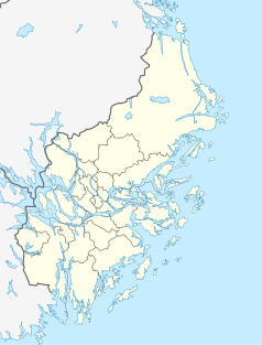
Location map of Stockholm County in Sweden
Equirectangular projection, N/S stretching 197 %. Geographic limits of the map:
- N: 60.30° N
- S: 58.70° N
- W: 17.10° E
- E: 19.50° E
Autor: Lokal_Profil
, Licencja: CC BY-SA 2.5
This coat of arms was drawn based on its blazon which – being a written description – is free from copyright. Any illustration conforming with the blazon of the arms is considered to be heraldically correct. Thus several different artistic interpretations of the same coat of arms can exist. The design officially used by the armiger is likely protected by copyright, in which case it cannot be used here.
Individual representations of a coat of arms, drawn from a blazon, may have a copyright belonging to the artist, but are not necessarily derivative works.
(c) Lokal_Profil, CC BY-SA 2.5
This coat of arms was drawn based on its blazon which – being a written description – is free from copyright. Any illustration conforming with the blazon of the arms is considered to be heraldically correct. Thus several different artistic interpretations of the same coat of arms can exist. The design officially used by the armiger is likely protected by copyright, in which case it cannot be used here.
Individual representations of a coat of arms, drawn from a blazon, may have a copyright belonging to the artist, but are not necessarily derivative works.


