Obserwatorium Paryskie
| ||
 | ||
| Państwo | ||
|---|---|---|
| Region | ||
| Miejscowość | Paryż | |
| Typ budynku | obserwatorium astronomiczne | |
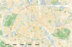
Położenie na mapie Paryża (c) Eric Gaba, Wikimedia Commons user Sting, CC BY-SA 3.0 | ||
| Strona internetowa | ||
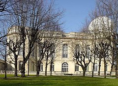
Obserwatorium Paryskie (fr. Observatoire de Paris albo Observatoire de Paris-Meudon) – obserwatorium astronomiczne we Francji i jeden z największych astronomicznych ośrodków na świecie.
Administracyjnie jest to grand établissement („znakomita firma”) pod opieką ministerstwa, kształcąca studentów z wyższym wykształceniem, ze statusem zamkniętego publicznego uniwersytetu. Jego misje obejmują:
- badania astronomiczne i astrofizyczne
- edukację (cztery programy magisterskie, doktor filozofii nauki)
- popularyzację nauki.
Obserwatorium jest siedzibą słonecznego obserwatorium przy Meudon i radioastronomicznego obserwatorium przy Nançay. W latach 1913-1987 było siedzibą Międzynarodowego Biura Czasu[1].
Historia
Podstawowe fundamenty obserwatorium zapoczątkował Jean-Baptiste Colbert, który chciał poszerzać morską potęgę Francji i handel międzynarodowy w XVII wieku. Ludwik XIV był promotorem uruchomienia budowy, która zaczęła się w 1667 a zakończyła się w 1671. Architektem był prawdopodobnie Claude Perrault, którego brat, Karol, był sekretarzem Colberta i kierownikiem robót publicznych. Optyczne przyrządy zostały zapewnione przez Giuseppe Campaniego. Budynki zostały rozbudowane w 1730, 1810, 1834, 1850 i 1951. Ostatnim powiększeniem był pokój południkowy zaprojektowany przez Jeana Prouvé. W 1863 obserwatorium wydało pierwszą współczesną mapę pogodową.
Dyrektorzy
- Giovanni Cassini (1671-1712) (początkowo stanowisko zaproponowano Janowi Heweliuszowi, który odmówił)
- Jacques Cassini (1712-1756)
- César François Cassini de Thury (1756-1784)
- Jean-Dominique Cassini (1784-1793)
- Jean Pemy Villeneuve, p.o. dyrektora (1793-ok. 1794)
- Nicolas-Antoine Nouet, p.o. dyrektora (ok. 1794-1795)
- Jérôme Lalande (1795-1800)
- Pierre Méchain (1800-1804)
- Jean Baptiste Joseph Delambre (1804-1822)
- Alexis Bouvard (1822-1843)
- François Arago (1843-1853)
- Urbain Le Verrier (1854-1870)
- Charles-Eugène Delaunay (1870-1873)
- Urbain Le Verrier (1873-1877)
- Amédée Mouchez (1878-1892)
- Félix Tisserand (1892-1896)
- Maurice Loewy (1896-1907)
- Benjamin Baillaud (1908-1926)
- Henri-Alexandre Deslandres (1926-1929)
- Ernest Esclangon (1929-1944)
- André Danjon (1945-1963)
- Jean-François Denisse (1963-1967)
- Jean Delhaye (1967-1971)
- Raymond Michard (1971-1976)
- Jacques Boulon (1976-1981)
- Pierre Charvin (1981-1991)
- Michel Combes (1991-1999)
- Pierre Couturier (1999-2003)
- Daniel Egret (2003-2011)
- Claude Catala (2011-)
Przypisy
- ↑ Bernard Guinot, History of the Bureau International de l'Heure, „Historical and Scientific Problems, ASP Conference Series,”, 208, IAU Colloquium #178. Edited by Steven Dick, Dennis McCarthy, and Brian Luzum. (San Francisco: ASP), 2000, s. 175–184, ISBN 1-58381-039-0, Bibcode: 2000ASPC..208..175G (ang.).???
Linki zewnętrzne
- Witryna internetowa Obserwatorium Paryskiego (ang. • fr.)
Media użyte na tej stronie
Autor: Superbenjamin, Licencja: CC BY-SA 4.0
Blank administrative map of France for geo-location purpose, with regions and departements distinguished. Approximate scale : 1:3,000,000
Autor: Thibault Pelloquin, Licencja: CC BY-SA 3.0
Cette carte représente l'Île de France (en jaune pâle), ses limites départementales et régionales (en traits gris) et ses principaux cours et points d'eau (en bleu). Les départements limitrophes (sont en rose-orange pâle)
(c) Eric Gaba, Wikimedia Commons user Sting, CC BY-SA 3.0
Blank land cover map of the city and department of Paris, France, as in January 2012, for geo-location purpose, with distinct boundaries for departments and arrondissements.
Autor: Patricia.fidi, Licencja: CC0
Unofficial (de facto) flag of the region Île-de-France in France. It was also the flag of the kingdom of France (s.XIV-XV)


