Obszar metropolitalny Los Angeles
Obszar metropolitalny Los Angeles, znany także jako Metropolia Los Angeles albo Southland[1], jest trzynastym co do wielkości obszarem metropolitalnym na świecie i drugą co do wielkości metropolią w Stanach Zjednoczonych[2]. Znajduje się w południowej części amerykańskiego stanu Kalifornia.
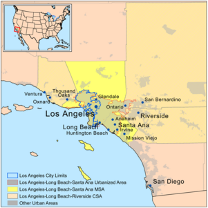
Obszar metropolitalny jest zdefiniowany przez Office of Management and Budget jako statystyczna metropolia Los Angeles - Long Beach - Santa Ana, złożona z hrabstw Los Angeles i Orange, statystyczny obszar metropolitalny wykorzystywany jest do celów statystycznych United Census Bureau oraz inne agencje[3]. Jego powierzchnia wynosi 12,562 km².
Hrabstwa Los Angeles i Orange są dwoma najludniejszymi hrabstwami Kalifornii. W 2010 roku w hrabstwie Los Angeles mieszkało 9,819 mln ludzi i było to najbardziej zaludnione hrabstwo w Stanach Zjednoczonych. Metropolia Los Angeles jest domem dla 15,4 milionów ludzi co czyni go najludniejszym obszarem metropolitalnym w zachodniej części Stanów Zjednoczonych i jednym z największych na terenie całych Stanów Zjednoczonych. Metropolia ta ma największy obszar miejski pod względem liczby mieszkańców w Stanach Zjednoczonych, Los Angeles - Long Beach - Santa Ana, zurbanizowany obszar zdefiniowany przez Census Buearaeu i liczy 12 828 837 mieszkańców według spisu powszechnego z 2010 roku.
Census Bureau definiuje również większy obszar w oparciu o wzory dróg dojazdowych, obszar statystyczny Los Angeles - Long Beach - Riverside, szerzej znany jako Greater Los Angeles Area, którego populacja szacowana jest na 17,786,419.[4]
Miasta
Główne miasta
Więcej informacji: Lista dzielnic i osiedli Los Angeles
Poniżej mieści się lista głównych miast w aglomeracji Los Angeles ze zaznaczoną liczbą mieszkańców (stan na rok 2009) według Kalifornijskiego Departamentu Finansów (California Department of Finance):[5]
- Los Angeles–Long Beach–Santa Ana MSA
|
|
|
Turystyka
Parki tematyczne
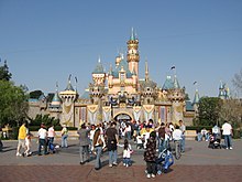
- Disneyland
- Disney California Adventure Park
- Knott's Berry Farm
- Pacific Park
- Six Flags Magic Mountain
- Universal Studios Hollywood
Plaże
- Malibu
- Venice Beach
- Huntington Beach
- Laguna Beach
- Dana Point
- Sunset Beach
- Bolsa Chica State Beach
- Newport Beach
- Manhattan Beach
- Hermosa Beach
- Redondo Beach
- San Clemente
- Santa Monica
Zakupy
- Americana at Brand
- Anaheim GardenWalk
- Bella Terra
- Beverly Center
- Cerritos Auto Square
- Cerritos Towne Center
- Citadel Outlets
- Downtown Disney
- Fashion Island
- Glendale Galleria
- The Grove at Farmer's Market
- Hollywood and Highland
- Irvine Spectrum Center
- Los Cerritos Center
- Old Pasadena
- Ontario Mills
- The Outlets at Orange
- Paseo Colorado
- Rodeo Drive
- The Shops at Mission Viejo
- South Coast Plaza
- Stonewood Center
- Third Street Promenade
- Universal CityWalk
- Valencia Town Center
- Victoria Gardens
- Westfield Century City
- Westfield MainPlace
- Westfield Santa Anita
- Westfield Topanga
- Westside Pavilion
Studia filmowe
- CBS Television City
- CBS Studio Center
- CBS Columbia Square
- Charlie Chaplin Studios
- Ren-Mar Studios
- Paramount Pictures
- NBC Studios
- Walt Disney Studios
- Golden Oak Ranch
- Hollywood Center Studios
- Universal Studios
- The Prospect Studios
- Metromedia Square
- Santa Clarita Studios
- Nestor Studios
- 20th Century Fox
- Sony Pictures Entertainment
- Fox Television Center
- Nickelodeon Animation Studio
- Sunset Gower Studios
- Downey Studios
- Warner Bros.
Parki wodne
- Raging Waters
- Knott's Soak City USA
- Six Flags Hurricane Harbor
Ogrody zoologiczne i parki
- Los Angeles Zoo
- Santa Ana Zoo
- Aquarium of the Pacific
Życie nocne
Muzea
- Bowers Museum
- Heritage Square Museum
- California Science Center
- Discovery Science Center
- Getty Center
- Getty Villa
- Griffith Observatory
- Huntington Library
- La Brea Tar Pits
- Los Angeles County Museum of Art
- Natural History Museum of Los Angeles County
- Norton Simon Museum
- Kidspace Children's Museum
- Museum of Contemporary Art, Los Angeles
- Museum of Latin American Art
- Museum of Tolerance
- Petersen Automotive Museum
- Toyota USA Automobile Museum
Muzea prezydenckie
- Richard Nixon Presidential Library and Museum
- Ronald Reagan Presidential Library
Inne
Zobacz też
Przypisy
- ↑ List of Southland's worst schools released | abc7.com, abclocal.go.com [dostęp 2017-11-15] [zarchiwizowane z adresu 2013-12-02] (ang.).
- ↑ Largest Metropolitan Areas in the U.S, geography.about.com [dostęp 2017-11-15].
- ↑ Current Lists of Metropolitan and Micropolitan Statistical Areas and Definitions. United States Census Bureau. 25 grudnia 2009
- ↑ Combined Statistical Area Population Estimates File for Internet Display. W: US Census Bureau [on-line]. 2006. [dostęp 2008-04-14].
- ↑ Zarchiwizowana kopia. [dostęp 2010-06-18]. [zarchiwizowane z tego adresu (2010-06-18)].
Media użyte na tej stronie
Autor: Anthony Giorgio, Licencja: CC BY 2.5
Photo of an interesting topiary on Two Rodeo in Beverly Hills, CA. This photo was taken at about the halfway point up the street.
Autor: Kmusser, Licencja: CC BY-SA 3.0
A map of the Greater Los Angeles Area in Southern California.
- The light gray shading indicates urbanized areas with Greater Los Angeles as defined by urbanized areas outlined in red.
- The Metropolitan Statistical Area is shown in yellow.
- The Combined Statistical Area includes the MSA plus those counties that are partially shaded.
Autor: en:User:Rebell18190, Licencja: CC-BY-SA-3.0
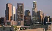
Photo taken on March 9th, 2007 at the vista point at Universal Studios Hollywood. The closest structures are the sound stages of the Warner Bros. Studio Lot. Directly behind them, with only the roofs showing, are the sound stages of the Walt Disney Studios lot, with the ABC Television building directly to the right. The aspect of this angle is approximately East-Northeast.
Autor: Oryginalnym przesyłającym był Geographer z angielskiej Wikipedii, Licencja: CC BY 1.0
Los Angeles Zoo - A summer crowd of LA Zoo, on August 7, 2005
3-D Perspective image of the Los Angeles Basin from the Landsat satellite using NASA's Shuttle Radar Topography Mission (SRTM) for topography information. The vertical scale is exaggerated one and half times.
Autor: Original uploader was Geographer at en.wikipedia, Licencja: CC BY 2.5
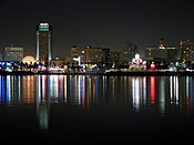
Downtown en:Long Beach, California at night Photographed and uploaded by user:Geographer.
Autor: Kevin Zollman --Kzollman 00:37, 21 February 2006 (UTC), Licencja: CC-BY-SA-3.0
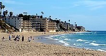
Languna Beach, California
Autor: Mfield, Matthew Field, http://www.photography.mattfield.com, Licencja: CC-BY-SA-3.0
A panorama of Los Angeles, California from the mountains to the ocean, taken from the Getty Center on an exceptionally clear day, intersected by the 405 freeway. Among the visible landmarks are the Sunset Strip, Downtown, Wilshire strip, UCLA, Century City, Westwood and the coastline stretching down to Marina Del Ray and LAX with the Palos Verdes peninsula and Catalina Island in the distance. Stitched from 12 images, original is 22000x3300
Disneyland Castle with 50th anniversary decorations.
