Okeechobee (jezioro)
| Ten artykuł od 2014-04 wymaga zweryfikowania podanych informacji. |
| ||
 | ||
| Położenie | ||
| Państwo | ||
|---|---|---|
| Stan | ||
| Lokalizacja | Półwysep Floryda | |
| Morfometria | ||
| Powierzchnia | 1890 km² | |
| Głębokość • maksymalna | 6 m | |
| Hydrologia | ||
| Rodzaj jeziora | krasowe | |
| 26°56′00″N 80°48′00″W/26,933333 -80,800000 | ||
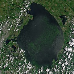
Okeechobee (ang. Okeechobee Lake) – jezioro w Ameryce Północnej, na terenie USA, na Półwyspie Floryda, w sąsiedztwie bagien Everglades. Powierzchnia 1890 km², głębokość do 6 m. Jezioro pochodzenia krasowego, połączone kanałami z Oceanem Atlantyckim, odwadniane do Zatoki Meksykańskiej.
Historia
Nazwa "Okeechobee" pochodzi ze słów Hitchiti "oki" (woda) i "chubi" (duży), czyli "duża woda". Jest otoczony wałami przeciwpowodziowymi, które zostały przerwane podczas huraganu Okeechobee w 1928 roku.
Media użyte na tej stronie
Autor: Uwe Dedering, Licencja: CC BY-SA 3.0
Relief location map of the USA (without Hawaii and Alaska).
EquiDistantConicProjection : Central parallel :
* N: 37.0° N
Central meridian :
* E: 96.0° W
Standard parallels:
* 1: 32.0° N
* 2: 42.0° N
Made with Natural Earth. Free vector and raster map data @ naturalearthdata.com.
Formulas for x and y:
x = 50.0 + 124.03149777329222 * ((1.9694462586094064-({{{2}}}* pi / 180))
      * sin(0.6010514667026994 * ({{{3}}} + 96) * pi / 180))
y = 50.0 + 1.6155950752393982 * 124.03149777329222 * 0.02613325650382181
      - 1.6155950752393982  * 124.03149777329222 *
     (1.3236744353715044  - (1.9694462586094064-({{{2}}}* pi / 180))
      * cos(0.6010514667026994 * ({{{3}}} + 96) * pi / 180))
The flag of Navassa Island is simply the United States flag. It does not have a "local" flag or "unofficial" flag; it is an uninhabited island. The version with a profile view was based on Flags of the World and as a fictional design has no status warranting a place on any Wiki. It was made up by a random person with no connection to the island, it has never flown on the island, and it has never received any sort of recognition or validation by any authority. The person quoted on that page has no authority to bestow a flag, "unofficial" or otherwise, on the island.
Autor: Tzugaj, Licencja: CC0
znak graficzny do map, ukazujący przykładowe jezioro
Autor: Eric Gaba (Sting - fr:Sting), Licencja: CC BY-SA 3.0
Blank physical map of the State of Florida, USA, for geo-location purpose, with counties boundaries.
The blue-green algae bloom is visible in this image of Lake Okeechobee, acquired on July 2, 2016, by the Operational Land Imager (OLI) on the Landsat 8 satellite. The natural-color image combines red light, green light, and coastal aerosol (blue) light (bands 4, 3 and 1).


