Olympus Mons
 | |
| Planeta | Mars |
|---|---|
| Położenie | region Tharsis |
| Wysokość | 21 287,4[1] m nad poziom odniesienia |
| Wybitność | około 26 000 m |
| Dane wulkanu | |
| Rok erupcji | 100–200 mln lat temu |
| Typ wulkanu | wulkan tarczowy |
| Aktywność | wygasły |
Położenie na mapie Marsa  | |
Olympus Mons (Góra Olimp) – najwyższa znana góra w Układzie Słonecznym, położona na Marsie.
Olympus Mons jest wygasłym wulkanem tarczowym, powstałym w wyniku powolnego i długotrwałego wycieku lawy, przez co jego zbocze jest nachylone pod małym kątem – 5 stopni[2] (takie wulkany można znaleźć także na Wenus i na Ziemi; np. Mauna Kea na Hawajach). Wznosi się na 21 287 metrów[1] ponad średnią powierzchnię planety i 25–27 kilometrów nad otaczającą go równinę[3][4]. Na tej wysokości ciśnienie atmosferyczne jest mniejsze od 0,1 ciśnienia na powierzchni Marsa, ale i tak szczyt może być pokryty chmurami zestalonego dwutlenku węgla[5]. Olympus Mons mierzy 624 km średnicy u podstawy, wyraźnie zaznaczonej skarpami o wysokości dochodzącej do 6 km[6]. Znajdujący się na wierzchołku krater ma długość 85 km, szerokość 60 km oraz głębokość 3 km. Na szczycie znajdują się liczne zapadliska[5].
Według danych obserwacyjnych pochodzących z sondy Mars Global Surveyor do ostatniej erupcji doszło 100–200 milionów lat temu[7]. Krążąca wokół Marsa sonda Mars Express pozwoliła ustalić przypuszczalny wiek zestalonej lawy na zboczach wulkanu na od 115 do zaledwie 2 mln lat[5].

Wulkan jest w regionie zwanym Aureolą Olympus Mons, poprzecinanym znaczących rozmiarów grzbietami i blokami skalnymi, rozciągającymi się do 1000 km od szczytu.
Duża wysokość Olympus Mons związana jest prawdopodobnie z brakiem płyt tektonicznych, przez co lawa wypływała w jednym miejscu przez nieporównywalnie dłuższy czas niż wynosi przeciętna aktywność takiego wulkanu na Ziemi[6].
Zobacz też
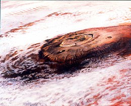
Olympus Mons otoczony chmurami, pokolorowana mozaika zdjęć z sondy Viking 1

Zdjęcie z Mars Global Surveyor
 (c) ESA/DLR/FU Berlin (G. Neukum), CC BY-SA 3.0 igo
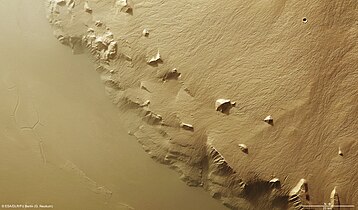
Skarpa po południowo-wschodniej stronie, zdjęcie Mars Express

Porównanie rozmiaru Olympus Mons do rozmiaru Polski
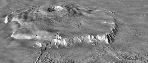
Topografia Olympus Mons, skala pionowa dziesięciokrotnie zwiększona w stosunku do rzeczywistej


Przypisy
- ↑ a b David E. Smith i inni, Mars Orbiter Laser Altimeter: Experiment summary after the first year of global mapping of Mars, „Journal of Geophysical Research: Planets”, 106 (E10), 2001, DOI: 10.1029/2000JE001364 [dostęp 2021-05-05] [zarchiwizowane z adresu 2021-05-05] (ang.).
- ↑ National Geographic – Najwyższe szczyty Układu Słonecznego.
- ↑ Highest and Lowest Points on Mars. [dostęp 2016-08-18].
- ↑ Space Facts – Olympus Mons.
- ↑ a b c Kosmos. Warszawa: Buchmann, 2012, s. 64. ISBN 978-83-7670-323-7.
- ↑ a b Olympus Mons. JPL.
- ↑ Linda M.V. Martel: Recent Activity on Mars: Fire and Ice (ang.). Planetary Science Research Discoveries (PSRD), 2005-01-31. [dostęp 2016-01-12].
Media użyte na tej stronie

Black up-pointing triangle ▲, U+25B2 from Unicode-Block Geometric Shapes (25A0–25FF)

Autor:
- Poland_location_map.svg: NordNordWest
- Olympus_Mons_alt.jpg: Image by NASA, modifications by Seddon
- derivative work: Szczureq
Porównanie powierzchni Polski i wulkanu Olympus Mons na Marsie
A composite image of Olympus Mons on Mars, the tallest known volcano and mountain in the Solar System.
A colorized topographic map of the martian shield volcano Olympus Mons, together with its surrounding aureole, from the Mars Orbiter Laser Altimeter (MOLA) instrument of the Mars Global Surveyor spacecraft. Olympus Mons, the largest volcano in the Solar System, lies in the western part of the volcanic province Tharsis. The volcanoes Alba Mons and Pavonis Mons lie just beyond the upper right and lower right corners of the image, respectively.
Some of the features in this image are annotated in Wikimedia Commons.
.svg)
Carte de Mars reconstituée à partir des mesures de Mars Global Surveyor (MOLA) et des observations de Viking.

(c) ESA/DLR/FU Berlin (G. Neukum), CC BY-SA 3.0 igo
A portion of the southeastern flank of Olympus Mons as imaged by the High Resolution Stereo Camera on ESA’s Mars Express on 21 January 2013 (orbit 11524), with a ground resolution of approximately 17 m per pixel. The image centre is located at approximately 14°N / 229°E. North is to the right. The image highlights the stark contrast between the hundreds of narrow, individual lava flows on the flanks of the volcano, and the smooth lava plains that surround it.

This painting, based on a mosaic of black-and-white Viking Orbiter images of Olympus Mons, shows the volcano's flanks and complex caldera protruding above thin clouds of water ice.