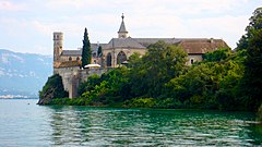
Opactwo Hautecombe
 | |
| Państwo | |
|---|---|
| Miejscowość | |
| Kościół | |
| Właściciel | Cystersi (1135-1792) |
| Prowincja | |
| Eparchia | |
| Założyciel klasztoru | |
| Fundator | |
| Styl | |
| Materiał budowlany | |
| Data budowy | 1135 |
| Data zamknięcia | 1792 |
| Data reaktywacji | 1826 |
| Strona internetowa klasztoru | |
Opactwo Hautecombe (fr. Abbaye d'Hautecombe) – ufundowany na początku XII wieku cysterski klasztor położony niedaleko Saint-Pierre-de-Curtille, w departamencie Sabaudia w regionie Rodan-Alpy we Francji[1][2],
Historia
Fundacja
Opactwo ufundowano w 1125 roku[3], ale pierwotnie opactwo znajdowało się w Cessens[4].
Średniowiecze
Założenie filii świadczyło też o szybkim wzroście liczby mnichów w klasztorze Hautecombe po czwartej krucjaty, wiele klasztorów zostało założone w Grecji: Zaraka(fr.)[5], Isova(fr.)[6], Petra(fr.)[7].
Opat komendatoryjny
Rewolucja francuska
Klasztor w dużej mierze upadł po rewolucji francuskiej. Opactwo zostało podniesione z ruiny przez Karola Emanuela IV, króla Sardynii księcia Piemontu, który kupił je (1824) i polecił następnie wyremontować Ernestowi Melano z przeznaczeniem na rodowe mauzoleum[2].
Architektura
Przypisy
- ↑ Tripomatic, Opactwo Hautecombe w Saint-Pierre-de-Curtille, Francja, travel.sygic.com [dostęp 2021-02-01].
- ↑ a b Opactwo Hautecombe, AWERS - REWERS [dostęp 2021-02-01] (pol.).
- ↑ Épiscopat de Arducius de Faucigny. [dostęp 2016-05-24]..
- ↑ Clair 2010 ↓, s. 11.
- ↑ Un demi-millénaire… Entre médiocrité et décadence. [dostęp 2012-06-26]..
- ↑ Beihammer, Parani i Schabel 2008 ↓, s. 108.
- ↑ Raymond Janin, Notes d'Histoire et de topographie — L'abbaye cistercienne « Saint-Ange de Pétra » (1214-1261), 1968, ISSN 0766-5598 [dostęp 2013-05-10]..
Bibliografia
- Alexander Daniel Beihammer, Maria G. Parani, Christopher David Schabel: Diplomatics in the Eastern Mediterranean 1000-1500. Brill, 2008. ISBN 978-90-04-16547-2. [dostęp 2016-05-04]. (ang.)
- Maria Ludovica Vertona: Hautecombe, Il restauro ottocentesco. Centro Studi Piemontesi, 2009. ISBN 978-88-8262-144-5. (wł.)
- Romain Clair: Hautecombe. Société d’art et d’histoire d'Aix-les-Bains, 2010. ISBN 978-2951969179. (fr.)
Media użyte na tej stronie
Autor: Superbenjamin, Licencja: CC BY-SA 4.0
Blank administrative map of France for geo-location purpose, with regions and departements distinguished. Approximate scale : 1:3,000,000
Blue Shield - the Distinctive emblem for the Protection of Cultural Property. The distinctive emblem is a protective symbol used during armed conflicts. Its use is restricted under international law.
Symbol klasztoru do legendy mapy
Autor: Martin Leveneur, Licencja: CC BY-SA 3.0
This building is indexed in the base Mérimée, a database of architectural heritage maintained by the French Ministry of Culture, under the reference PA00118305


