Ouachita River
 Tama na Ouachita w Columbia, Luizjana | ||||||||||
| Kontynent | ||||||||||
|---|---|---|---|---|---|---|---|---|---|---|
| Państwo | ||||||||||
| Rzeka | ||||||||||
| Długość | 976[1] km | |||||||||
| Średni przepływ | ||||||||||
| Źródło | ||||||||||
| Miejsce | Góry Ouachita, Hrabstwo Polk, Arkansas | |||||||||
| Współrzędne | ||||||||||
| Ujście | ||||||||||
| Recypient | Red River | |||||||||
| Miejsce | okolica Jonesville, Parafia Catahoula | |||||||||
| Wysokość | 12 m n.p.m.[3] | |||||||||
| Współrzędne | ||||||||||
| Mapa | ||||||||||
 | ||||||||||
| Szlak | ||||||||||
| ||||||||||
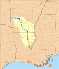
Ouachita (ang. Ouachita River, Washita River[1]) – rzeka w amerykańskich stanach Arkansas i Luizjana, uchodzi do Red River – dopływu Missisipi. Od połączenia z rzeką Tensas River nazywana jest także Black River[1]. Nazwa rzeki pochodzi od plemienia Indian Ouachita zamieszkujących niegdyś dolinę rzeki (Ouachita Valley) w Arkansas[4].
Zobacz też
Przypisy
- ↑ a b c d Ouachita River, [w:] Encyclopædia Britannica [online] [dostęp 2015-01-04] (ang.).
- ↑ Arkansas River, Station: Monroe, LA. Global River Discharge Database. [dostęp 2015-01-02]. (ang.).
- ↑ Feature Detail Report for: Ouachita River. US Geographic Names Information System, U.S. Geological Survey. [dostęp 2015-01-04]. (ang.).
- ↑ Lake Ouachita Indian Mounds. Native American Genealogy. [dostęp 2015-01-02]. [zarchiwizowane z tego adresu (2015-01-04)]. (ang.).
Media użyte na tej stronie
The flag of Navassa Island is simply the United States flag. It does not have a "local" flag or "unofficial" flag; it is an uninhabited island. The version with a profile view was based on Flags of the World and as a fictional design has no status warranting a place on any Wiki. It was made up by a random person with no connection to the island, it has never flown on the island, and it has never received any sort of recognition or validation by any authority. The person quoted on that page has no authority to bestow a flag, "unofficial" or otherwise, on the island.
Autor: Pfly, Licencja: CC BY-SA 2.5
This is a map of the Ouachita River watershed — in Arkansas and Louisiana.
- Tributary of the Mississippi River.
- Credits
Columbia Lock and Dam on the Ouachita River in Columbia, Louisiana, USA. The U.S. Army Corps of Engineers maintains the locks and dredges the river to maintain a navigation channel on the river.
Autor: Uwe Dedering, Licencja: CC BY-SA 3.0
Relief location map of the USA (without Hawaii and Alaska).
EquiDistantConicProjection : Central parallel :
* N: 37.0° N
Central meridian :
* E: 96.0° W
Standard parallels:
* 1: 32.0° N
* 2: 42.0° N
Made with Natural Earth. Free vector and raster map data @ naturalearthdata.com.
Formulas for x and y:
x = 50.0 + 124.03149777329222 * ((1.9694462586094064-({{{2}}}* pi / 180))
      * sin(0.6010514667026994 * ({{{3}}} + 96) * pi / 180))
y = 50.0 + 1.6155950752393982 * 124.03149777329222 * 0.02613325650382181
      - 1.6155950752393982  * 124.03149777329222 *
     (1.3236744353715044  - (1.9694462586094064-({{{2}}}* pi / 180))
      * cos(0.6010514667026994 * ({{{3}}} + 96) * pi / 180))


