Oxfordshire
| Hrabstwo ceremonialne i niemetropolitalne | |||||
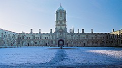
 Kolegium Christ Church, należące do Uniwersytetu Oksfordzkiego, w stolicy hrabstwa | |||||
| |||||
| Dewiza: Sapere Aude (z łac. Odważ się być mądrym) | |||||
| Państwo | |||||
|---|---|---|---|---|---|
| Kraj | |||||
| Region | |||||
| Siedziba | |||||
| Powierzchnia | 2605 km² | ||||
| Populacja (2011) • liczba ludności |
| ||||
| • gęstość | 251,0 os./km² | ||||
| Szczegółowy podział administracyjny | |||||
 | |||||
| Liczba dystryktów | 5 | ||||
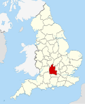
Położenie na mapie | |||||
| Strona internetowa | |||||
| Portal | |||||
Oxfordshire – hrabstwo administracyjne (niemetropolitalne), ceremonialne i historyczne w środkowej Anglii, w regionie South East England.
Powierzchnia hrabstwa wynosi 2605 km², a liczba ludności – 653 800 (2011)[1]. Stolicą i największym miastem, jedynym posiadającym status city, jest Oksford, położony w środkowej części hrabstwa. Innymi większymi miastami na terenie Oxfordshire są Banbury, Abingdon-on-Thames i Bicester.
Zachodnią część hrabstwa zajmują wzgórza Cotswolds. Na terenie hrabstwa znajduje się wpisana na listę światowego dziedzictwa UNESCO posiadłość Blenheim Palace.
Na zachodzie Oxfordshire graniczy z hrabstwem Gloucestershire, na północnym zachodzie z Warwickshire, na północnym wschodzie z Northamptonshire, na wschodzie z Buckinghamshire, na południu z Berkshire, a na południowym zachodzie z Wiltshire.
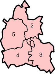
Podział administracyjny
W skład hrabstwa wchodzi pięć dystryktów.
Okręgi wyborcze
Mapa
Przypisy
- ↑ Table P04 2011 Census: Usual resident population by five-year age group, local authorities in England and Wales. Office for National Statistics. [dostęp 2012-07-24]. (ang.).
- ↑ Office for National Statistics: KS101EW - Usual resident population. [w:] 2011 Census [on-line]. Nomis – Official labour market statistics, 2013-02-12. [dostęp 2022-06-05]. (ang.).
- ↑ Office for National Statistics: Built-up Area to Local Authority District (December 2011) Lookup in England and Wales. [w:] Open Geography Portal [on-line]. [dostęp 2022-06-05]. (ang.).
- ↑ Office for National Statistics: Built-up Area Sub Divisions (December 2011) Boundaries. [w:] Open Geography Potal [on-line]. [dostęp 2022-06-05]. (ang.).
Bibliografia
- Oxfordshire, [w:] Encyclopædia Britannica [online] [dostęp 2011-09-05] (ang.).
Media użyte na tej stronie
Flag of England. Saint George's cross (a red cross on a white background), used as the Flag of England, the Italian city of Genoa and various other places.
Autor:
- vector-images.com
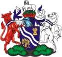
The Coat of arms of Oxfordshire County Council, the top-tier authority for the county of Oxfordshire, in South East England.
Autor: Toby Ord, Licencja: CC BY-SA 2.5
Tom Quad at Christ Church, Oxford on a beautiful snowy day.
Autor: Nilfanion, Licencja: CC BY-SA 3.0
Location of the ceremonial county of Oxfordshire within England.
Contains Ordnance Survey data © Crown copyright and database right, CC BY-SA 3.0
Map of Oxfordshire, UK with the following information shown:
- Administrative borders
- Coastline, lakes and rivers
- Roads and railways
- Urban areas
Equirectangular map projection on WGS 84 datum, with N/S stretched 160%
Geographic limits:
- West: 1.74W
- East: 0.72W
- North: 52.19N
- South: 51.44N


