Pałac w Pniowie
.JPG) Ruiny pałacu | |
| Państwo | |
|---|---|
| Miejscowość | |
| Typ budynku | |
| Ukończenie budowy | XVIII w. |
Położenie na mapie gminy Toszek _location_map.png "Mapa lokalizacyjna gminy Toszek") | |
Położenie na mapie Polski  (c) Karte: NordNordWest, Lizenz: Creative Commons by-sa-3.0 de | |
Położenie na mapie województwa śląskiego  | |
Położenie na mapie powiatu gliwickiego  | |
Pałac w Pniowie – wybudowany w XVIII w., w miejscowości Pniów[1].
Historia
Obiekt jest częścią zespołu pałacowego, w skład którego wchodzi jeszcze park.
Galeria

Ruiny pałacu


Brama pałacowa
Ruiny folwarku
Ruiny folwarku
Przypisy
- ↑ Rejestr zabytków nieruchomych woj. śląskiego. Narodowy Instytut Dziedzictwa. [dostęp 2015-11-20].
Media użyte na tej stronie
Poland adm location map.svg
(c) Karte: NordNordWest, Lizenz: Creative Commons by-sa-3.0 de
Location map of Poland
(c) Karte: NordNordWest, Lizenz: Creative Commons by-sa-3.0 de
Location map of Poland
Silesian Voivodeship location map2.svg
Autor: SANtosito, Licencja: CC BY-SA 4.0
Location map of en:Silesian Voivodeship with counties (powiats) and municipalities (gminas). Geographic limits of the map:
Autor: SANtosito, Licencja: CC BY-SA 4.0
Location map of en:Silesian Voivodeship with counties (powiats) and municipalities (gminas). Geographic limits of the map:
- N: 51.1617 N
- S: 49.2956 N
- W: 17.8872 E
- E: 20.0559 E

Distinctive emblem for cultural property.svg
Blue Shield - the Distinctive emblem for the Protection of Cultural Property. The distinctive emblem is a protective symbol used during armed conflicts. Its use is restricted under international law.
Blue Shield - the Distinctive emblem for the Protection of Cultural Property. The distinctive emblem is a protective symbol used during armed conflicts. Its use is restricted under international law.


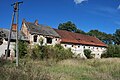
Pniów ruiny pałacu 05.06.2011 3p.jpg
Autor: Przykuta, Licencja: CC BY-SA 3.0
Pniów - ruina barokowego pałacu (zabytek nr A/291/60 z 7.03.1960)
Autor: Przykuta, Licencja: CC BY-SA 3.0
Pniów - ruina barokowego pałacu (zabytek nr A/291/60 z 7.03.1960)
.JPG)
Pniów, pozostałości parku pałacowego, brama (4).JPG
Autor: Bazie, Licencja: CC BY-SA 3.0 pl
Pniów, park, XVIII/XIX w.
Autor: Bazie, Licencja: CC BY-SA 3.0 pl
Pniów, park, XVIII/XIX w.
.JPG)
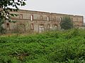
A 291 60 z 7.03.1960 Pałac wraz z założeniem parkowym Pniów (3).JPG
Autor: KristofferS, Licencja: CC BY-SA 3.0 pl
Pniów - zabudowania dworskie, ruiny (zabytek nr A/291/60 z 7.03.1960)
Autor: KristofferS, Licencja: CC BY-SA 3.0 pl
Pniów - zabudowania dworskie, ruiny (zabytek nr A/291/60 z 7.03.1960)
.JPG)
.JPG)
Gliwice County location map02.svg
Autor: SANtosito, Licencja: CC BY-SA 4.0
Location map of Gliwice County with urbanized area highlighted. Geographic limits of the map:
Autor: SANtosito, Licencja: CC BY-SA 4.0
Location map of Gliwice County with urbanized area highlighted. Geographic limits of the map:
- N: 50.56 N
- S: 50.16 N
- W: 18.33 E
- E: 18.83 E