Pacific Highway
| Długość | 825 km | |||||||||||||||||||||||||||||||||||||||||||||||||||||||||||||||||||||||||||||||||||||||||||||||||||||||||||||||||||||||||||||||||||||||||||||||||||||||||||||||||||||||||||||||||||||||||||||||||||||||||
|---|---|---|---|---|---|---|---|---|---|---|---|---|---|---|---|---|---|---|---|---|---|---|---|---|---|---|---|---|---|---|---|---|---|---|---|---|---|---|---|---|---|---|---|---|---|---|---|---|---|---|---|---|---|---|---|---|---|---|---|---|---|---|---|---|---|---|---|---|---|---|---|---|---|---|---|---|---|---|---|---|---|---|---|---|---|---|---|---|---|---|---|---|---|---|---|---|---|---|---|---|---|---|---|---|---|---|---|---|---|---|---|---|---|---|---|---|---|---|---|---|---|---|---|---|---|---|---|---|---|---|---|---|---|---|---|---|---|---|---|---|---|---|---|---|---|---|---|---|---|---|---|---|---|---|---|---|---|---|---|---|---|---|---|---|---|---|---|---|---|---|---|---|---|---|---|---|---|---|---|---|---|---|---|---|---|---|---|---|---|---|---|---|---|---|---|---|---|---|---|---|---|---|
| Stany i terytoria | ||||||||||||||||||||||||||||||||||||||||||||||||||||||||||||||||||||||||||||||||||||||||||||||||||||||||||||||||||||||||||||||||||||||||||||||||||||||||||||||||||||||||||||||||||||||||||||||||||||||||||
| Mapa | ||||||||||||||||||||||||||||||||||||||||||||||||||||||||||||||||||||||||||||||||||||||||||||||||||||||||||||||||||||||||||||||||||||||||||||||||||||||||||||||||||||||||||||||||||||||||||||||||||||||||||
 | ||||||||||||||||||||||||||||||||||||||||||||||||||||||||||||||||||||||||||||||||||||||||||||||||||||||||||||||||||||||||||||||||||||||||||||||||||||||||||||||||||||||||||||||||||||||||||||||||||||||||||
| Zdjęcie | ||||||||||||||||||||||||||||||||||||||||||||||||||||||||||||||||||||||||||||||||||||||||||||||||||||||||||||||||||||||||||||||||||||||||||||||||||||||||||||||||||||||||||||||||||||||||||||||||||||||||||
 Tablica w Sydney | ||||||||||||||||||||||||||||||||||||||||||||||||||||||||||||||||||||||||||||||||||||||||||||||||||||||||||||||||||||||||||||||||||||||||||||||||||||||||||||||||||||||||||||||||||||||||||||||||||||||||||
| ||||||||||||||||||||||||||||||||||||||||||||||||||||||||||||||||||||||||||||||||||||||||||||||||||||||||||||||||||||||||||||||||||||||||||||||||||||||||||||||||||||||||||||||||||||||||||||||||||||||||||
| Strona internetowa drogi | ||||||||||||||||||||||||||||||||||||||||||||||||||||||||||||||||||||||||||||||||||||||||||||||||||||||||||||||||||||||||||||||||||||||||||||||||||||||||||||||||||||||||||||||||||||||||||||||||||||||||||
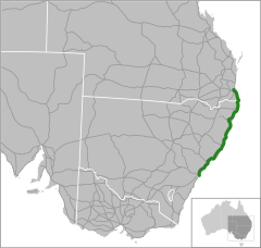
Pacific Highway – nazwa drogi łączącej Sydney w Nowej Południowej Walii z Brisbane w Queenslandzie, przebiegającej wzdłuż wybrzeża Pacyfiku w Australii. Jest częścią szlaku Highway 1.[1]
Oznakowanie
Pacific Highway wchodzi w skład kilku różnych dróg z oznaczeniem numerycznym:
– droga metropolitarna 1 – w aglomeracji Sydney, na odcinku od osiedla Artarmon do osiedla Wahroonga
– droga stanowa 83 – na odcinku z Sydney do San Remo
– droga stanowa 111 – z San Remo do Hexham
– droga krajowa 1 – z Hexham do granicy Nowej Południowej Walii i Queenslandu
(W związku z trwającym przechodzeniem stanu Nowa Południowa Walia na nowy system numeracji dróg, powyższe oznaczenia mogą być używane zamiennie z nowym: ![]() droga stanowa A1)
droga stanowa A1)
droga stanowa M1 – od granicy stanów do Brisbane
– droga metropolitarna 1 (ponownie) – na ostatnim odcinku, już w Brisbane
Mapa
- Mapa. rta.nsw.gov.au. [zarchiwizowane z tego adresu (2009-09-14)].
Kamera
- Sydney (Chatswood)
Przypisy
Media użyte na tej stronie
Sign no. 392 - Customs, darker version
prom rzeka-icon.
(Motorway) tunnel Icon. Drawing similar to Swiss road signs.
Gas station symbol
AIGA Air Transportation sign (inverted)
Location of Australia's Pacific Highway
Image of an Australian Route 44 shield.
Australian Alphanumeric State Route A1
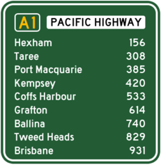
Distances to destinations along the Pacific Highway from Sydney.
Autor: Cgoodwin, Licencja: CC BY-SA 3.0
The southbound Hexham Bridge on the Pacific Highway in New South Wales, Australia, is the largest of few surviving lift span bridges in New South Wales and is still in working order. The bridge, which is one of two bridges over the Hunter River at this point, is seen from the northern approach in Tomago, New South Wales. Both of the Hexham bridges are actually in the suburb of Tarro, while the northern and southern approaches are in Tomago and Hexham respectively.NSW Department of Lands - Spatial Information Exchange
Image of an Australian Route 1 shield.
Image of an Australian Route 34 shield.
Image of an Australian Route 38 shield.
Australian Alphanumeric State Route M1
Autor: Techelf z angielskiej Wikipedii, Licencja: CC-BY-SA-3.0
NSW Metroad route 1 (M1) marker.
Autor: Mike Young, Licencja: CC BY-SA 4.0
Bridge on the old Pacific Highway at Taree, now bypassed but still used for local traffic.


