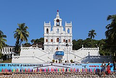
Panaji
| Ten artykuł od 2011-06 wymaga zweryfikowania podanych informacji. |
 | |
| Państwo | |
|---|---|
| Stan | |
| Populacja • liczba ludności |
|
| Nr kierunkowy | 832 |
| Kod pocztowy | 403001 |
Położenie na mapie Indii | |
| Strona internetowa | |
Panaji (hindi पणजी, trb.: Panadźi, trl.: Paṇajī; ang. Panaji, dawniej Panjim) – miasto w Indiach, stolica stanu Goa. Położone nad estuarium rzeki Mandovi niedaleko od Morza Arabskiego. Zamieszkane jest przez 65 000 osób (trzecie co do wielkości miasto stanu).
Miasto zostało założone na miejscu małej wioski Pangem i nazwane w 1843 Nova Goa po tym jak stało się stolicą Indii Portugalskich. Po przyłączeniu Goa do Indii od 1961 było stolicą związkowego terytorium Goa, Daman i Diu, a od 1987 stanu Goa.
Media użyte na tej stronie
(c) Uwe Dedering z niemieckiej Wikipedii, CC BY-SA 3.0
Location map of India.
Equirectangular projection. Strechted by 106.0%. Geographic limits of the map:
- N: 37.5° N
- S: 5.0° N
- W: 67.0° E
- E: 99.0° E
The Flag of India. The colours are saffron, white and green. The navy blue wheel in the center of the flag has a diameter approximately the width of the white band and is called Ashoka's Dharma Chakra, with 24 spokes (after Ashoka, the Great). Each spoke depicts one hour of the day, portraying the prevalence of righteousness all 24 hours of it.
Autor: Sailko, Licencja: CC BY 3.0
Religious buildings in Panaji
Autor:
- Goa_locator_map.svg: by User:Planemad
- derivative work: User:Milenioscuro
Location map of Goa Geographic limits of the map:
- 15.816°N
- 14.892°N
- 73.554°E
- 74.353°E


