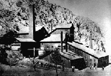
Panamint City
| ||
 Panamint City | ||
| Państwo | ||
| Stan | ||
| Hrabstwo | Inyo | |
| Data założenia | 1873–1874 | |
| Wysokość | 1921 m n.p.m. | |
| Populacja • liczba ludności | 0 | |
| Portal | ||
Panamint City – opuszczone miasto w hrabstwie Inyo stanu Kalifornia, dokładnie w Panamint Range, blisko Doliny Śmierci i ok. 3 mile na północny zachód od Peak Sentinel.
Powstało w latach 1873–1874. Szybko powstały fabryki, sklepy, dzielnica czerwonych latarni. Pod koniec XIX wieku liczba mieszkańców wyniosła 2000. Wydawało także własną gazetę, Panamint News. Podstawą gospodarki było wydobycie srebra. Panamint City cieszyło się złą opinią ze względu na częste napady. W związku z tym górnicy przetapiali wydobyte srebro na wielkie sztaby, których kradzież była prawie niemożliwa.
24 lipca 1876 roku powódź zniszczyła prawie całe miasto. Do roku 1983 władze hrabstwa utrzymywały drogę do Panamint City. Zaprzestano, gdy ulewne deszcze spowodowały falę powodziową, która całkowicie wymyła kanion. Teraz możliwy jest dojazd wyłącznie samochodami terenowymi z napędem na cztery koła.
Dzisiaj stanowi atrakcję dla entuzjastów miast duchów, wyposażonych w odpowiednie pojazdy i sprzęt pomagający przetrwać.
Linki zewnętrzne
Media użyte na tej stronie
Autor: NordNordWest, Licencja: CC BY 3.0
Location map of California, USA
Autor: Uwe Dedering, Licencja: CC BY-SA 3.0
Location map of the USA (without Hawaii and Alaska).
EquiDistantConicProjection:
Central parallel:
* N: 37.0° N
Central meridian:
* E: 96.0° W
Standard parallels:
* 1: 32.0° N
* 2: 42.0° N
Made with Natural Earth. Free vector and raster map data @ naturalearthdata.com.
Formulas for x and y:
x = 50.0 + 124.03149777329222 * ((1.9694462586094064-({{{2}}}* pi / 180))
      * sin(0.6010514667026994 * ({{{3}}} + 96) * pi / 180))
y = 50.0 + 1.6155950752393982 * 124.03149777329222 * 0.02613325650382181
      - 1.6155950752393982  * 124.03149777329222 *
     (1.3236744353715044  - (1.9694462586094064-({{{2}}}* pi / 180))
      * cos(0.6010514667026994 * ({{{3}}} + 96) * pi / 180))
The flag of Navassa Island is simply the United States flag. It does not have a "local" flag or "unofficial" flag; it is an uninhabited island. The version with a profile view was based on Flags of the World and as a fictional design has no status warranting a place on any Wiki. It was made up by a random person with no connection to the island, it has never flown on the island, and it has never received any sort of recognition or validation by any authority. The person quoted on that page has no authority to bestow a flag, "unofficial" or otherwise, on the island.
Flag of California. This version is designed to accurately depict the standard print of the bear as well as adhere to the official flag code regarding the size, position and proportion of the bear, the colors of the flag, and the position and size of the star.
Panamint City was once called the toughest, rawest, most hard-boiled little hellhole that ever passed for a civilized town.


