Park Narodowy Black Canyon of the Gunnison
| ||
 | ||
| park narodowy | ||
| Państwo | ||
| Położenie | Kolorado | |
| Siedziba | Gunnison, Kolorado | |
| Data utworzenia | 1999 | |
| Powierzchnia | 133 km² | |
| Odwiedzający | 175 852 (2013)[1] | |
 | ||
| Strona internetowa | ||
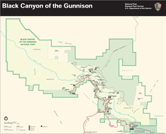
Park Narodowy Black Canyon of the Gunnison (ang. Black Canyon of the Gunnison National Park) – park narodowy położony w USA w zachodniej części stanu Kolorado. Park został utworzony w 1999 na powierzchni 133 km².
Historia
Decyzją prezydenta Herberta Hoovera obszar kanionu został objęty ochroną 2 marca 1933 roku jako pomnik narodowy Black Canyon of the Gunnison National Monument. Granice pomnika zmieniano w 1938, 1939 i 1960 roku, zaś w 1999 roku jego rangę podniesiono do parku narodowego ustanawiając Park Narodowy Black Canyon of the Gunnison[2].
Fauna
Na terenie Parku Narodowego Black Canyon of the Gunnison występuje wiele dzikich gatunków, wśród których można wymienić: puchacza wirginijskiego, modrosójkę czarnogłową, sokoła wędrownego.
Turystyka
Infrastruktura turystyczna parku jest stosunkowo dobrze rozwinięta. Park posiada kemping oraz kilka kilometrów szlaków turystycznych. W parku możliwe jest również uprawianie wspinaczki.
Zobacz też
Przypisy
- ↑ Sprawozdania roczne - podsumowanie liczby odwiedzających (ang.). National Park Service. [dostęp 2014-08-24].
- ↑ Monuments list National Park Service (ang.)
Linki zewnętrzne
- Oficjalna strona internetowa Parku Narodowego Black Canyon of the Gunnison (ang.)
- Informacje o Parku Narodowym Black Canyon of the Gunnison (ang.)
| ||||||||||||||
Media użyte na tej stronie
Autor: Uwe Dedering, Licencja: CC BY-SA 3.0
Relief location map of the USA (without Hawaii and Alaska).
EquiDistantConicProjection : Central parallel :
* N: 37.0° N
Central meridian :
* E: 96.0° W
Standard parallels:
* 1: 32.0° N
* 2: 42.0° N
Made with Natural Earth. Free vector and raster map data @ naturalearthdata.com.
Formulas for x and y:
x = 50.0 + 124.03149777329222 * ((1.9694462586094064-({{{2}}}* pi / 180))
      * sin(0.6010514667026994 * ({{{3}}} + 96) * pi / 180))
y = 50.0 + 1.6155950752393982 * 124.03149777329222 * 0.02613325650382181
      - 1.6155950752393982  * 124.03149777329222 *
     (1.3236744353715044  - (1.9694462586094064-({{{2}}}* pi / 180))
      * cos(0.6010514667026994 * ({{{3}}} + 96) * pi / 180))
The flag of Navassa Island is simply the United States flag. It does not have a "local" flag or "unofficial" flag; it is an uninhabited island. The version with a profile view was based on Flags of the World and as a fictional design has no status warranting a place on any Wiki. It was made up by a random person with no connection to the island, it has never flown on the island, and it has never received any sort of recognition or validation by any authority. The person quoted on that page has no authority to bestow a flag, "unofficial" or otherwise, on the island.
Shiny green button/marker widget.
Autor: NordNordWest, Licencja: CC BY 3.0
Location map of Colorado, USA
Autor: http://www.terraprints.com, Licencja: CC BY 2.5
The raw satellite imagery shown in these images was obtain from NASA and/or the US Geological Survey. Post-processing and production by www.terraprints.com
Autor: www.Gernot-Keller.com (User: Gernot Keller), London, Licencja: CC BY 3.0
USA, Colorado, Black Canyon
Map of Black Canyon of the Gunnison National Park
Autor: G. Edward Johnson, Licencja: CC-BY-SA-3.0
Tomichi Point, Black Canyon of the Gunnison N.P., Colorado


