Park Narodowy Gates of the Arctic
 | |
| park narodowy | |
| Państwo | |
|---|---|
| Stan | |
| Siedziba | Bettles, Alaska |
| Data utworzenia | |
| Powierzchnia | 34287 km² |
| Odwiedzający | 11 012 (2013)[1] |
 | |
| Strona internetowa | |
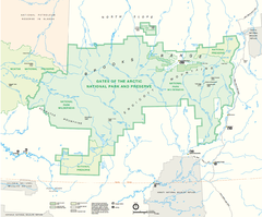
Park Narodowy Gates of the Arctic (ang. Gates of the Arctic National Park and Preserve) – park narodowy położony w północnej części stanu Alaska w Stanach Zjednoczonych. Park został utworzony w 1980 na powierzchni 34 287 km². Nazwa parku w wolnym tłumaczeniu oznacza „Wrota Arktyki”.
Na terenie parku nie ma dróg, szlaków ani żadnej infrastruktury turystycznej. Jednakże, w odległości ok. 8 km od wschodniej granicy parku przebiega autostrada Alaska State Highway 11. Władze parku prowadzą małe centrum turystyczne w pobliżu miejscowości Coldfoot.
Przypisy
- ↑ Sprawozdania roczne - podsumowanie liczby odwiedzających. National Park Service. [dostęp 2014-08-24]. (ang.).
Zobacz też
Linki zewnętrzne
- Oficjalna strona internetowa Parku Narodowego Gates Of The Arctic (ang.)
- Zdjęcia Parku Narodowego Gates of the Arctic – Terra Galleria (ang.)
Media użyte na tej stronie
Autor: Uwe Dedering, Licencja: CC BY-SA 3.0
Relief location map of North America.
- Projection: Lambert azimuthal equal-area projection.
- Area of interest:
- N: 90.0° N
- S: 5.0° N
- W: -140.0° E
- E: -60.0° E
- Projection center:
- NS: 47.5° N
- WE: -100.0° E
- GMT projection: -JA-100/47.5/20.0c
- GMT region: -R-138.3726888474925/-3.941007863604182/2.441656573833029/50.63933645705661r
- GMT region for grdcut: -R-220.0/-4.0/20.0/90.0r
- Relief: SRTM30plus.
- Made with Natural Earth. Free vector and raster map data @ naturalearthdata.com.
The flag of Navassa Island is simply the United States flag. It does not have a "local" flag or "unofficial" flag; it is an uninhabited island. The version with a profile view was based on Flags of the World and as a fictional design has no status warranting a place on any Wiki. It was made up by a random person with no connection to the island, it has never flown on the island, and it has never received any sort of recognition or validation by any authority. The person quoted on that page has no authority to bestow a flag, "unofficial" or otherwise, on the island.
Shiny green button/marker widget.
Map of the Gates of the Arctic National Park, Alaska
Gates of the Arctic in Summer - Aerial View
Autor: Uwe Dedering, Licencja: CC BY-SA 3.0
Relief location map of North America.
- Projection: Lambert azimuthal equal-area projection.
- Area of interest:
- N: 90.0° N
- S: 5.0° N
- W: -140.0° E
- E: -60.0° E
- Projection center:
- NS: 47.5° N
- WE: -100.0° E
- GMT projection: -JA-100/47.5/20.0c
- GMT region: -R-138.3726888474925/-3.941007863604182/2.441656573833029/50.63933645705661r
- GMT region for grdcut: -R-220.0/-4.0/20.0/90.0r
- Relief: SRTM30plus.
- Made with Natural Earth. Free vector and raster map data @ naturalearthdata.com.
Autor: Wikisoft* @@@-fr 07:08, 27 April 2011 (UTC), Licencja: GFDL
Carte Alaska Relief R3 jpg (Changement des couleurs)


