Park Narodowy Katmai
 | |
| park narodowy | |
| Państwo | |
|---|---|
| Stan | |
| Siedziba | King Salmon, Alaska |
| Data utworzenia | |
| Powierzchnia | 19122 km² |
| Odwiedzający | 28 966 (2013)[1] |
 | |
| Strona internetowa | |
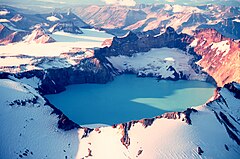
Park Narodowy Katmai (ang. Katmai National Park and Preserve) – park narodowy położony w południowej części stanu Alaska w Stanach Zjednoczonych. Założony 2 grudnia 1980. Park zajmuje powierzchnię 19 122 km². Centralnym miejscem parku jest wulkan Katmai, natomiast inspiracją do jego powstania (wcześniej jako narodowego pomnika USA) była Dolina Dziesięciu Tysięcy Dymów – pamiątka wybuchu wulkanu Novarupta w 1912 roku.
Fauna
Na terenie Parku Narodowego Katmai występuje jedna z największych chronionych populacji niedźwiedzia brunatnego, których liczbę szacuje się na ok. 2000 osobników.
Ponadto na terenie parku występują m.in.: wilki, łosie, karibu, łososie oraz pstrągi.
Przypisy
- ↑ Sprawozdania roczne - podsumowanie liczby odwiedzających. National Park Service. [dostęp 2014-08-24]. (ang.).
Linki zewnętrzne
- Oficjalna strona internetowa Parku Narodowego Katmai (ang.)
- Park Narodowy Katmai na Terra Gelleria (ang.)
Media użyte na tej stronie
The flag of Navassa Island is simply the United States flag. It does not have a "local" flag or "unofficial" flag; it is an uninhabited island. The version with a profile view was based on Flags of the World and as a fictional design has no status warranting a place on any Wiki. It was made up by a random person with no connection to the island, it has never flown on the island, and it has never received any sort of recognition or validation by any authority. The person quoted on that page has no authority to bestow a flag, "unofficial" or otherwise, on the island.
Shiny green button/marker widget.
Autor: Uwe Dedering, Licencja: CC BY-SA 3.0
Relief location map of North America.
- Projection: Lambert azimuthal equal-area projection.
- Area of interest:
- N: 90.0° N
- S: 5.0° N
- W: -140.0° E
- E: -60.0° E
- Projection center:
- NS: 47.5° N
- WE: -100.0° E
- GMT projection: -JA-100/47.5/20.0c
- GMT region: -R-138.3726888474925/-3.941007863604182/2.441656573833029/50.63933645705661r
- GMT region for grdcut: -R-220.0/-4.0/20.0/90.0r
- Relief: SRTM30plus.
- Made with Natural Earth. Free vector and raster map data @ naturalearthdata.com.
Official National Park Service map of Katmai National Park and Preserve, Alaska. Converted from PDF using Adobe Acrobat 7.0 Professional. Original file name:
KATMmap1.pdf Autor: Wikisoft* @@@-fr 07:08, 27 April 2011 (UTC), Licencja: GFDL
Carte Alaska Relief R3 jpg (Changement des couleurs)


