Park Narodowy Skamieniałego Lasu
 | |
| park narodowy | |
| Państwo | |
|---|---|
| Stan | |
| Położenie | |
| Data utworzenia | |
| Powierzchnia | 884 km² |
| Odwiedzający | 644 648 (2013)[1] |
 | |
| Strona internetowa | |
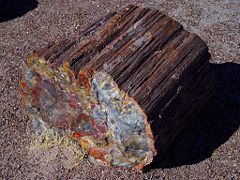
Park Narodowy Skamieniałego Lasu (ang. Petrified Forest National Park) – park narodowy położony w Stanach Zjednoczonych, w stanie Arizona, na terenie Pustyni Pstrej[2]. Nazwa parku pochodzi od licznych egzemplarzy skrzemieniałego drewna, które występują na jego obszarze.
Obszar parku został pierwotnie objęty ochroną decyzją prezydenta Theodore’a Roosevelta z 8 grudnia 1906, który utworzył w tym regionie pomnik narodowy pod nazwą Petrified Forest National Monument. Granice pomnika były później kilkakrotnie zmieniane. Ostatecznie Kongres Stanów Zjednoczonych decyzją z 28 marca 1958 podniósł rangę obszaru chronionego do parku narodowego, ustanawiając Park Narodowy Skamieniałego Lasu. Proces legislacyjny trwał kilka lat i ostatecznie park narodowy powstał 9 grudnia 1962. Granice obszaru objętego ochroną po raz kolejny uległy zmianie w 2006, gdy prezydent George W. Bush powiększył powierzchnię parku z 379 km² do 884 km²[3].
Przypisy
- ↑ Sprawozdania roczne - podsumowanie liczby odwiedzających. National Park Service. [dostęp 2014-08-24]. (ang.).
- ↑ Painted Desert, [w:] Encyclopædia Britannica [online] [dostęp 2017-01-19] (ang.).
- ↑ Petrified Forest National Park - Brief Administrative History National Park Service (ang.)
Media użyte na tej stronie
The flag of Navassa Island is simply the United States flag. It does not have a "local" flag or "unofficial" flag; it is an uninhabited island. The version with a profile view was based on Flags of the World and as a fictional design has no status warranting a place on any Wiki. It was made up by a random person with no connection to the island, it has never flown on the island, and it has never received any sort of recognition or validation by any authority. The person quoted on that page has no authority to bestow a flag, "unofficial" or otherwise, on the island.
Shiny green button/marker widget.
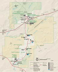
Map of Petrified Forest National Park — in northeastern Arizona, United States.
- The park is made of colorful and highly erodable Chinle Formation deposits; a 200 Ma year non-deposition occurred at the park, then the Bidahochi Formation, lake deposits and later volcanic tuffs (air fall deposits).
- The Bidahochi Formation is erosion-resistant and can form en:caprocks on specific landforms, or landslide deposits at their base and flanks.
Autor: Finetooth, Licencja: CC BY-SA 3.0
The Tepees in Petrified Forest National Park in northeastern Arizona, United States. View is toward the northwest from the main park road. According to a National Park Service (NPS) document, rock strata exposed in the Tepees area of the park belong to the Blue Mesa Member of the Chinle Formation and are about 220 to 225 million years old. The colorful bands of mudstone and sandstone were laid down during the Triassic, when the area was part of a huge tropical floodplain.
Autor: SANtosito, Licencja: CC BY-SA 4.0
Relief location map of Arizona, USA
Geographic limits of the map:
- N: 37.3° N
- S: 31.1° N
- W: 115.0° W
- E: 108.7° W
Autor: Uwe Dedering, Licencja: CC BY-SA 3.0
Relief location map of the USA (without Hawaii and Alaska).
EquiDistantConicProjection : Central parallel :
* N: 37.0° N
Central meridian :
* E: 96.0° W
Standard parallels:
* 1: 32.0° N
* 2: 42.0° N
Made with Natural Earth. Free vector and raster map data @ naturalearthdata.com.
Formulas for x and y:
x = 50.0 + 124.03149777329222 * ((1.9694462586094064-({{{2}}}* pi / 180))
      * sin(0.6010514667026994 * ({{{3}}} + 96) * pi / 180))
y = 50.0 + 1.6155950752393982 * 124.03149777329222 * 0.02613325650382181
      - 1.6155950752393982  * 124.03149777329222 *
     (1.3236744353715044  - (1.9694462586094064-({{{2}}}* pi / 180))
      * cos(0.6010514667026994 * ({{{3}}} + 96) * pi / 180))


