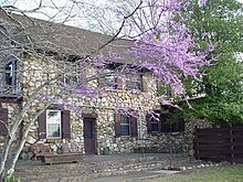
Park stanowy F. D. Roosevelta
| ||
 | ||
| park narodowy | ||
| Państwo | ||
| Położenie | Hrabstwo Harris Georgia | |
| Data utworzenia | 1934 | |
| Powierzchnia | 36,62 km² | |
| Strona internetowa | ||
Park stanowy F. D. Roosevelta (ang. F. D. Roosevelt State Park) – park stanowy w amerykańskim stanie Georgia. Leży około 120 km na południe od miasta Atlanta na terenie hrabstwa Harris[1]. Jest największym parkiem stanowym w Georgii, leży w pobliżu miejscowości Pine Mountain oraz Warm Springs. Nazwa parku została na część Prezydenta USA Franklina D. Roosevelta, który mieszkając nieopodal w Little White House leczył w okolicy paraplegię spowodowaną rozpoznaną u niego chorobą Heinego-Medina. Park został zbudowany przez paramilitarny Cywilny Korpus Konserwacji (Civilian Conservation Corps) utworzony w ramach pomocy społecznej w okresie Wielkiego kryzysu.
Przypisy
- ↑ U.S. Geological Survey Geographic Names Information System: Franklin D Roosevelt State Park (ang.). [dostęp 2012-08-28].
Linki zewnętrzne
- Strona oficjalna (ang.)
Media użyte na tej stronie
Autor: Uwe Dedering, Licencja: CC BY-SA 3.0
Relief location map of the USA (without Hawaii and Alaska).
EquiDistantConicProjection : Central parallel :
* N: 37.0° N
Central meridian :
* E: 96.0° W
Standard parallels:
* 1: 32.0° N
* 2: 42.0° N
Made with Natural Earth. Free vector and raster map data @ naturalearthdata.com.
Formulas for x and y:
x = 50.0 + 124.03149777329222 * ((1.9694462586094064-({{{2}}}* pi / 180))
      * sin(0.6010514667026994 * ({{{3}}} + 96) * pi / 180))
y = 50.0 + 1.6155950752393982 * 124.03149777329222 * 0.02613325650382181
      - 1.6155950752393982  * 124.03149777329222 *
     (1.3236744353715044  - (1.9694462586094064-({{{2}}}* pi / 180))
      * cos(0.6010514667026994 * ({{{3}}} + 96) * pi / 180))
The flag of Navassa Island is simply the United States flag. It does not have a "local" flag or "unofficial" flag; it is an uninhabited island. The version with a profile view was based on Flags of the World and as a fictional design has no status warranting a place on any Wiki. It was made up by a random person with no connection to the island, it has never flown on the island, and it has never received any sort of recognition or validation by any authority. The person quoted on that page has no authority to bestow a flag, "unofficial" or otherwise, on the island.
Shiny green button/marker widget.
Autor: Bruce Rouslin, Licencja: CC BY-SA 3.0
Lodge at F.D. Roosevelt State Park
Autor: Thomsonmg2000, Licencja: CC0
FDR's statue in the F. D. Roosevelt State Park, Georgia.
Autor: Alexrk2, Licencja: CC BY 3.0
Ta mapa została stworzona za pomocą GeoTools.


