Parral
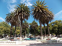
 Plaza de Armas w Parral | |||||
| |||||
| Państwo | |||||
|---|---|---|---|---|---|
| Region | |||||
| Powierzchnia | 9,87 km² | ||||
| Wysokość | 162 m n.p.m. | ||||
| Populacja (2002) • liczba ludności • gęstość |
| ||||
| Nr kierunkowy | 56-73 | ||||
| Kod pocztowy | 3630000 | ||||
| Strona internetowa | |||||
Parral – miasto w Chile, położone w południowej części regionu Maule.
Opis
Miejscowość została założona w 1795 roku. Przez miasto przebiega Droga Panamerykańska R5, R128 i linia kolejowa.
Demografia
Źródło.
Miasta partnerskie
Znani urodzenie w Parral
- Pablo Neruda - poeta, laureat Nagrody Nobla w dziedzinie literatury
Zobacz też
Media użyte na tej stronie
Łatwo można dodać ramkę naokoło tej grafiki
The flag of Navassa Island is simply the United States flag. It does not have a "local" flag or "unofficial" flag; it is an uninhabited island. The version with a profile view was based on Flags of the World and as a fictional design has no status warranting a place on any Wiki. It was made up by a random person with no connection to the island, it has never flown on the island, and it has never received any sort of recognition or validation by any authority. The person quoted on that page has no authority to bestow a flag, "unofficial" or otherwise, on the island.
Autor: Angel Diaz Cofré, Licencja: CC BY-SA 3.0
Plaza de Armas de Parral, VII Región del Maule


