Paso Robles
| ||
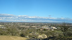
 Widok na Paso Robles | ||
| Państwo | ||
| Stan | ||
| Hrabstwo | San Luis Obispo | |
| Powierzchnia | 49,5 km² | |
| Populacja (2013) • liczba ludności • gęstość | 30 857 623,4 os./km² | |
| Nr kierunkowy | 805 | |
| Kod pocztowy | 93446 | |
| Strona internetowa | ||
| Portal | ||
Paso Robles (także El Paso de Robles[1]) – miasto (city) w hrabstwie San Luis Obispo, w południowo-zachodniej części stanu Kalifornia, w Stanach Zjednoczonych, położone nad rzeką Salinas. W 2013 roku miasto liczyło 30 857 mieszkańców[2].
Paso Robles położone jest w regionie winiarskim. W okolicy znajdują się także źródła termalne[1].
Nazwa miasta oznacza w języku hiszpańskim „dębową przełęcz”[1].
Przypisy
- ↑ a b c About the city (ang.). City of Paso Robles. [dostęp 2015-01-27].
- ↑ El Paso de Robles (Paso Robles) (city), California (ang.). QuickFacts from the US Census Bureau. [dostęp 2015-01-27].
Media użyte na tej stronie
Autor: NordNordWest, Licencja: CC BY 3.0
Location map of California, USA
Autor: Uwe Dedering, Licencja: CC BY-SA 3.0
Location map of the USA (without Hawaii and Alaska).
EquiDistantConicProjection:
Central parallel:
* N: 37.0° N
Central meridian:
* E: 96.0° W
Standard parallels:
* 1: 32.0° N
* 2: 42.0° N
Made with Natural Earth. Free vector and raster map data @ naturalearthdata.com.
Formulas for x and y:
x = 50.0 + 124.03149777329222 * ((1.9694462586094064-({{{2}}}* pi / 180))
      * sin(0.6010514667026994 * ({{{3}}} + 96) * pi / 180))
y = 50.0 + 1.6155950752393982 * 124.03149777329222 * 0.02613325650382181
      - 1.6155950752393982  * 124.03149777329222 *
     (1.3236744353715044  - (1.9694462586094064-({{{2}}}* pi / 180))
      * cos(0.6010514667026994 * ({{{3}}} + 96) * pi / 180))
The flag of Navassa Island is simply the United States flag. It does not have a "local" flag or "unofficial" flag; it is an uninhabited island. The version with a profile view was based on Flags of the World and as a fictional design has no status warranting a place on any Wiki. It was made up by a random person with no connection to the island, it has never flown on the island, and it has never received any sort of recognition or validation by any authority. The person quoted on that page has no authority to bestow a flag, "unofficial" or otherwise, on the island.
Flag of California. This version is designed to accurately depict the standard print of the bear as well as adhere to the official flag code regarding the size, position and proportion of the bear, the colors of the flag, and the position and size of the star.
Hilltop photo of Paso Robles. By Sam Houston.


