Peñalara
 | |
| Państwo | |
|---|---|
| Położenie | |
| Pasmo | |
| Wysokość | 2430 m n.p.m. |
| Wybitność | 1200 m |
Peñalara to najwyższy szczyt łańcucha górskiego Sierra de Guadarrama w hiszpańskich Górach Kastylijskich.
Na wschód od szczytu leży dolina Lozoya. Rejon szczytu jest parkiem natury.
Linki zewnętrzne
- Ascensión a Peñalara. geo.ya.com. [zarchiwizowane z tego adresu (2012-03-29)].
- Rutas por Peñalara y sus lagunas. rutasserranas.net. [zarchiwizowane z tego adresu (2008-08-01)].
Media użyte na tej stronie
Autor: Pedro A. Gracia Fajardo, escudo de Manual de Imagen Institucional de la Administración General del Estado, Licencja: CC0
Flaga Hiszpanii
Black up-pointing triangle ▲, U+25B2 from Unicode-Block Geometric Shapes (25A0–25FF)
Autor: Miguel303xm, Licencja: CC BY 3.0
Vertiente sur del macizo de Peñalara vista desde la cima del Cerro de Valdemartín (Sierra de Guadarrama, España).
Autor: Miguillen, Licencja: CC BY-SA 1.0
Location map relieve of Castile and León
Autor: Miguel303xm, Licencja: CC BY-SA 2.5
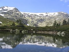
View of the circus of Peñalara and its reflection in the Small Lake (2,005 ms). As much this circus as the lake is of origin glacier, like more than twenty small lakes that sprinkle the Natural Reserve of Peñalara. This circus glacier is one of the formation more important glaciers of the Sierra de Guadarrama and the Central System (mountain range to which the Mountain range of Guadarrama belongs). In the superior end straight of the image it appears the summit of Peñalara, the highest mountain of the Mountain range of Guadarrama with his 2,430 meters of altitude. This mountain range is in the center of Spain.


